Geolocate

Henderson Point topographic map

Click on the map to display elevation.

About this map

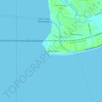
Name: Henderson Point topographic map, elevation, terrain.

Location: Henderson Point, Harrison County, Mississippi, United States (30.28502 -89.31055 30.32502 -89.27055)

Average elevation: 3 ft

Minimum elevation: -3 ft

Maximum elevation: 36 ft

Harrison County trails, hiking, mountain biking, running and outdoor activities

Other topographic maps

Click on a map to view its topography, its elevation and its terrain.

Biloxi

United States > Mississippi > Harrison County > Biloxi

Average elevation: 3 ft

Saucier

United States > Mississippi > Harrison County

Average elevation: 112 ft

Biloxi River

United States > Mississippi > Harrison County

Average elevation: 115 ft

Saucier

United States > Mississippi > Harrison County

Average elevation: 112 ft

Gear up for your next adventure:

🪶Fire Starter Kit - Reliable fire starter for survival and camping
📖Nature Tracking Books - Learn to track wildlife and terrain
🧤Tactile Hiking Gloves - Keep hands warm while operating GPS and smartphone screens
📱Heavy-Duty Phone Cases - Drop-proof and waterproof protection for outdoor navigation
🎒Waterproof Dry Bags - Keep your electronics and maps dry inside your pack

As an Amazon Associate, this site earns from qualifying purchases at no extra cost to you.