
Narmada topographic map
Interactive map
Click on the map to display elevation.
About this map
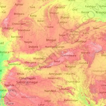
Name: Narmada topographic map, elevation, terrain.
Location: Narmada, 391105, India (21.65496 72.69258 23.14377 81.76477)
Average elevation: 1,250 ft
Minimum elevation: 0 ft
Maximum elevation: 4,724 ft
Other topographic maps
Click on a map to view its topography, its elevation and its terrain.
3d
India > Rajasthan > Ganganagar Tehsil > 1 LNP
3d, 1 LNP, Ganganagar Tehsil, Sri Ganganagar District, Rajasthan, India
Average elevation: 584 ft
Dehradun
India > Uttarakhand > Dehradun
Dehradun, Dehradun District, Uttarakhand, 248001, India
Average elevation: 2,966 ft
Keeranatham
India > Tamil Nadu > Coimbatore North
Keeranatham, Coimbatore North, Coimbatore District, Tamil Nadu, 641035, India
Average elevation: 1,355 ft
Mendhar
India > Jammu and Kashmir > Mendhar Tehsil
Mendhar, Mendhar Tehsil, Poonch District, Jammu and Kashmir, India
Average elevation: 3,583 ft
Anandapura
India > Karnataka > Sagara taluk
Anandapura, Sagara taluk, Shimoga District, Karnataka, 577412, India
Average elevation: 2,096 ft
Shangarh
India > Himachal Pradesh > Sainj
Shangarh, Sainj, Kullu District, Himachal Pradesh, India
Average elevation: 6,926 ft
Nidhraad
India > Gujarat > Sanand Taluka
Nidhraad, Sanand Taluka, Ahmedabad District, Gujarat, India
Average elevation: 138 ft
Taksing
India > Arunachal Pradesh > Taksing Circle
Taksing, Taksing Circle, Upper Subansiri District, Arunachal Pradesh, India
Average elevation: 10,302 ft
West Para
India > Kerala > Udumbanchola > Chottupara
West Para, Chottupara, Udumbanchola, Idukki District, Kerala, 685552, India
Average elevation: 3,087 ft
Udgir
Udgir, Latur District, Maharashtra, 413517, India
Average elevation: 1,847 ft
Dabri
India > Madhya Pradesh > Nagda Tahsil > Dabri
Dabri, Nagda Tahsil, Ujjain District, Madhya Pradesh, India
Average elevation: 1,598 ft
Korome
India > Kerala > Mananthavady
Korome, Mananthavady, Wayanad District, Kerala, 670731, India
Average elevation: 2,874 ft
Uthind
India > Uttarakhand > Ukhimath
Uthind, Ukhimath, Rudraprayag District, Uttarakhand, 246419, India
Average elevation: 5,253 ft
Rajkot West Taluka
Rajkot West Taluka, Rajkot District, Gujarat, India
Average elevation: 433 ft
Achalpur
Achalpur, Amravati District, Maharashtra, India
Average elevation: 1,480 ft
Siddipet
India > Telangana > Siddipet_Urban mandal
Siddipet, Siddipet_Urban mandal, Siddipet District, Telangana, 502103, India
Average elevation: 1,565 ft
Yavatmal District
Yavatmal District, Maharashtra, India
Average elevation: 1,076 ft
Chittaranjan
India > West Bengal > Salanpur
Chittaranjan, Salanpur, Paschim Bardhaman District, West Bengal, 713331, India
Average elevation: 512 ft
Dhupguri
Dhupguri, Jalpaiguri District, West Bengal, India
Average elevation: 466 ft
Amravati
Amravati, Amravati District, Maharashtra, India
Average elevation: 1,145 ft
Kulgaon Badlapur
India > Maharashtra > Ambernath Taluka
Kulgaon Badlapur, Ambernath Taluka, Thane District, Maharashtra, 421503, India
Average elevation: 187 ft
Yavatmal
Yavatmal, Yavatmal District, Maharashtra, 445300, India
Average elevation: 1,010 ft
Badlapur
Badlapur, Jaunpur District, Uttar Pradesh, India
Average elevation: 285 ft
Apipalle
India > Telangana > Kosgi mandal
Apipalle, Kosgi mandal, Narayanpet District, Telangana, India
Average elevation: 1,713 ft
Hinganghat
Hinganghat, Wardha District, Maharashtra, India
Average elevation: 764 ft
Barala
India > Rajasthan > Poogal Tehsil
Barala, Poogal Tehsil, Bikaner District, Rajasthan, India
Average elevation: 617 ft
Sonnappanahalli
India > Karnataka > Yelahanka taluku > Vidyanagar
Sonnappanahalli, Vidyanagar, Yelahanka taluku, Bengaluru Urban, Karnataka, India
Average elevation: 3,018 ft
Indian subcontinent
India > Maharashtra > Arni
Indian subcontinent, Arni, Yavatmal, Maharashtra, India
Average elevation: 1,155 ft
Rohru
Rohru, Shimla District, Himachal Pradesh, 171207, India
Average elevation: 7,474 ft
Patan
India > Maharashtra > Patan
Patan, Satara District, Maharashtra, 415206, India
Average elevation: 2,192 ft
Haripad
India > Kerala > Karthikappally
Haripad, Karthikappally, Alappuzha District, Kerala, 690514, India
Average elevation: 13 ft
Sheoganj
India > Rajasthan > Sheoganj Tehsil
Sheoganj, Sheoganj Tehsil, Sirohi District, Rajasthan, 306902, India
Average elevation: 889 ft
Pokaran
India > Rajasthan > Pokaran Tehsil
Pokaran, Pokaran Tehsil, Jaisalmer District, Rajasthan, India
Average elevation: 751 ft
Kuther
India > Jammu and Kashmir > Shangus tehsil
Kuther, Shangus tehsil, Anantnag District, Jammu and Kashmir, 192201, India
Average elevation: 6,109 ft
Awantipora
Awantipora, Pulwama District, Jammu and Kashmir, India
Average elevation: 5,463 ft
Singahalli
India > Karnataka > Kolar taluk
Singahalli, Kolar taluk, Kolar District, Karnataka, India
Average elevation: 2,799 ft
Delwara
India > Madhya Pradesh > Tyonda Tahsil
Delwara, Tyonda Tahsil, Vidisha District, Madhya Pradesh, India
Average elevation: 1,398 ft
Elimukku
India > Kerala > Kozhencherry
Elimukku, Kozhencherry, Pathanamthitta District, Kerala, 689504, India
Average elevation: 95 ft
Tral
Tral, Pulwama District, Jammu and Kashmir, 192123, India
Average elevation: 8,294 ft
Panner Jageer
India > Jammu and Kashmir > Tral
Panner Jageer, Tral, Pulwama District, Jammu and Kashmir, India
Average elevation: 6,631 ft
Jodhpur
India > Rajasthan > Jodhpur Tehsil
Jodhpur, Jodhpur Tehsil, Jodhpur District, Rajasthan, India
Average elevation: 781 ft
Malappuram
Malappuram, Ernad, Malappuram District, Kerala, India
Average elevation: 184 ft
Sreekandapuram
India > Kerala > Taliparamba
Sreekandapuram, Taliparamba, Kannur District, Kerala, 670631, India
Average elevation: 230 ft