
Oni, Georgia topographic map
Click on the map to display elevation.
About this map
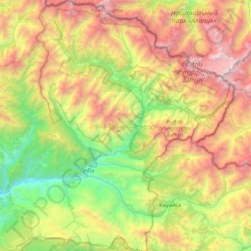
Name: Oni, Georgia topographic map, elevation, terrain.
Location: Oni, Georgia, Racha-Lechkhumi and Lower Svaneti, Georgia (42.43570 43.23767 42.89935 43.79587)
Average elevation: 6,965 ft
Minimum elevation: 2,037 ft
Maximum elevation: 15,098 ft
Other topographic maps
Click on a map to view its topography, its elevation and its terrain.
Ambrolauri
Georgia > Racha-Lechkhumi and Lower Svaneti > Ambrolauri Municipality
Ambrolauri (Georgian: ამბროლაური) is a city in Georgia, located in the northwestern part of the country, on both banks of the Rioni river, at an elevation of 550 m above sea level. The city serves as the seat of the Racha-Lechkhumi and Kvemo Svaneti regional administration and of the…
Average elevation: 2,047 ft