
Make a donation
Gear up for your next adventure:
As an Amazon Associate, this site earns from qualifying purchases at no extra cost to you.
Twixlum topographic map
Click on the map to display elevation.
Make a donation
Gear up for your next adventure:
As an Amazon Associate, this site earns from qualifying purchases at no extra cost to you.
About this map
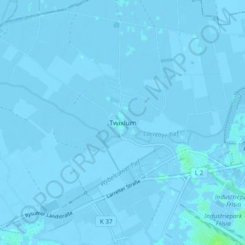
Name: Twixlum topographic map, elevation, terrain.
Location: Twixlum, Lower Saxony, 26723, Germany (53.35081 7.11355 53.39081 7.15355)
Average elevation: -3 ft
Minimum elevation: -16 ft
Maximum elevation: 23 ft
Make a donation
Gear up for your next adventure:
As an Amazon Associate, this site earns from qualifying purchases at no extra cost to you.
Other topographic maps
Click on a map to view its topography, its elevation and its terrain.
Hanover
Germany > Lower Saxony > Region Hannover
In 1636 George, Duke of Brunswick-Lüneburg, ruler of the Brunswick-Lüneburg principality of Calenberg, moved his residence to Hanover. The Dukes of Brunswick-Lüneburg were elevated by the Holy Roman Emperor to the rank of Prince-Elector in 1692 and this elevation was confirmed by the Imperial Diet in 1708.…
Average elevation: 200 ft
Make a donation
Gear up for your next adventure:
As an Amazon Associate, this site earns from qualifying purchases at no extra cost to you.
Garbsen
Germany > Lower Saxony > Region Hannover
Garbsen belongs to the Weser-Aller-Flachland natural area and is situated between the lowlands of the river Leine and the Otternhagener Moor. The differences in altitude are only a few metres.
Average elevation: 164 ft
Make a donation
Gear up for your next adventure:
As an Amazon Associate, this site earns from qualifying purchases at no extra cost to you.
Nationalpark Harz
Germany > Lower Saxony > Landkreis Goslar
Several rivers have their sources in the national park, including the Bode, the Oder and the Ilse, a tributary of the Oker. The waters of the Oder, flowing southwards, are collected in the historic Oderteich reservoir, finished in 1722 to supply the mines in Sankt Andreasberg, and feed the Oder Dam on the…
Average elevation: 1,749 ft
Make a donation
Gear up for your next adventure:
As an Amazon Associate, this site earns from qualifying purchases at no extra cost to you.
Make a donation
Gear up for your next adventure:
As an Amazon Associate, this site earns from qualifying purchases at no extra cost to you.
OS Hahnenklee-Bockswiese
Germany > Lower Saxony > Landkreis Goslar > Goslar
Average elevation: 1,886 ft
Clausthal-Zellerfeld
Germany > Lower Saxony > Landkreis Goslar
Clausthal-Zellerfeld (German pronunciation: [ˈklaʊstaːlˈtsɛlɐfɛlt] ) is a town in Lower Saxony, Germany. It is located in the southwestern part of the Harz mountains. Its population is approximately 15,000. The town hosts the Clausthal University of Technology. The health resort is located in the Upper…
Average elevation: 1,529 ft
Make a donation
Gear up for your next adventure:
As an Amazon Associate, this site earns from qualifying purchases at no extra cost to you.
Make a donation
Gear up for your next adventure:
As an Amazon Associate, this site earns from qualifying purchases at no extra cost to you.
Make a donation
Gear up for your next adventure:
As an Amazon Associate, this site earns from qualifying purchases at no extra cost to you.
Make a donation
Gear up for your next adventure:
As an Amazon Associate, this site earns from qualifying purchases at no extra cost to you.
Make a donation
Gear up for your next adventure:
As an Amazon Associate, this site earns from qualifying purchases at no extra cost to you.
Schüttorf
Germany > Lower Saxony > Landkreis Grafschaft Bentheim
The town of Schüttorf lies mainly on valley sand plates which are crossed by the Vechte Lowland, which is almost flush with them along this stretch. The lowland lies roughly 30 m above sea level and is from 200 to 500 m wide. Bordering its edges are river terraces with a height of roughly 35 m above sea…
Average elevation: 128 ft
Make a donation
Gear up for your next adventure:
As an Amazon Associate, this site earns from qualifying purchases at no extra cost to you.
Make a donation
Gear up for your next adventure:
As an Amazon Associate, this site earns from qualifying purchases at no extra cost to you.
Make a donation
Gear up for your next adventure:
As an Amazon Associate, this site earns from qualifying purchases at no extra cost to you.
Juist
Germany > Lower Saxony > Landkreis Aurich
Juist is accessible by plane or daily ferry. FLN Frisia Luftverkehr operates planes between Norden and Juist. Most motor vehicles are prohibited on the island, with only the fire department, the German Red Cross and doctors allowed to use them. Island tractors require a special license, while most other…
Average elevation: 0 ft
Garbsen
Germany > Lower Saxony > Region Hannover
Garbsen belongs to the Weser-Aller-Flachland natural area and is situated between the lowlands of the river Leine and the Otternhagener Moor. The differences in altitude are only a few metres.
Average elevation: 164 ft
Make a donation
Gear up for your next adventure:
As an Amazon Associate, this site earns from qualifying purchases at no extra cost to you.
Make a donation
Gear up for your next adventure:
As an Amazon Associate, this site earns from qualifying purchases at no extra cost to you.
Make a donation
Gear up for your next adventure:
As an Amazon Associate, this site earns from qualifying purchases at no extra cost to you.
Braunlage
Germany > Lower Saxony > Landkreis Goslar
Braunlage is located on the Warme Bode, a headstream of the river Bode, close to the border with Elend in the state of Saxony-Anhalt. The municipal area stretches along the south-eastern rim of the Harz National Park from an elevation of 550 m (1,800 ft) up to 971 m (3,186 ft) at the summit of the Wurmberg.…
Average elevation: 2,028 ft
Make a donation
Gear up for your next adventure:
As an Amazon Associate, this site earns from qualifying purchases at no extra cost to you.
Make a donation
Gear up for your next adventure:
As an Amazon Associate, this site earns from qualifying purchases at no extra cost to you.
Neu Wulmstorf
Germany > Lower Saxony > Harburg
Further up, the villages Wulmstorf, Daerstorf, Schwiederstorf, Rade are marking the highest elevations of Neu Wulmstorf on the western outskirts of the Harburg Hills.
Average elevation: 144 ft
Make a donation
Gear up for your next adventure:
As an Amazon Associate, this site earns from qualifying purchases at no extra cost to you.
Make a donation
Gear up for your next adventure:
As an Amazon Associate, this site earns from qualifying purchases at no extra cost to you.
Make a donation
Gear up for your next adventure:
As an Amazon Associate, this site earns from qualifying purchases at no extra cost to you.
Make a donation
Gear up for your next adventure:
As an Amazon Associate, this site earns from qualifying purchases at no extra cost to you.
Make a donation
Gear up for your next adventure:
As an Amazon Associate, this site earns from qualifying purchases at no extra cost to you.
Make a donation
Gear up for your next adventure:
As an Amazon Associate, this site earns from qualifying purchases at no extra cost to you.
Groß Ellershausen / Hetjershausen / Knutbühren
Germany > Lower Saxony > Landkreis Göttingen > Göttingen
Average elevation: 712 ft
Make a donation
Gear up for your next adventure:
As an Amazon Associate, this site earns from qualifying purchases at no extra cost to you.
Einbeck
Germany > Lower Saxony > Landkreis Northeim
In the Early Middle Ages a number of villages existed along the river Ilme in the middle Leine valley before Einbeck was founded. On January 1, 1158 Einbeck was first mentioned in a deed of Friedrich Barbarossa, which mentioned … in loco qui Einbike vocatur …. and related to a transfer of an estate in the…
Average elevation: 650 ft
Make a donation
Gear up for your next adventure:
As an Amazon Associate, this site earns from qualifying purchases at no extra cost to you.