
Blues Point topographic map
Click on the map to display elevation.
About this map
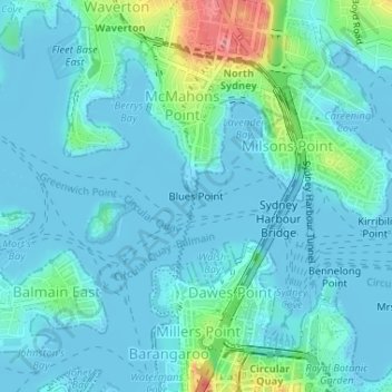
Name: Blues Point topographic map, elevation, terrain.
Location: Blues Point, Sydney, New South Wales, 2061, Australia (-33.85064 151.20389 -33.85054 151.20399)
Average elevation: 49 ft
Minimum elevation: -13 ft
Maximum elevation: 299 ft
Other topographic maps
Click on a map to view its topography, its elevation and its terrain.
Wentworth Falls
Australia > New South Wales > Sydney
Wentworth Falls (postcode: 2782) is a town in the Blue Mountains region of New South Wales, situated approximately 100 kilometres (62 mi) west of the Sydney central business district, and about 8 kilometres (5.0 mi) east of Katoomba, Australia on the Great Western Highway, with a Wentworth Falls railway…
Average elevation: 2,323 ft
Canterbury-Bankstown Council
Australia > New South Wales > Sydney
Within the same year 16 US fighter planes that were based at Bankstown airport flew over Canterbury racecourse at low altitude during a race meet. This was to let the Australian public, especially those of the district to know that they, their allies were there for their protection. Regardless of these events,…
Average elevation: 85 ft
Hyde Park
Australia > New South Wales > Sydney
We know it was timbered, as was the rest of the topography, from the early drawings of the settlement, and Director of the Botanic Gardens, Sydney J. H. Maiden has suggested that the dominant species were probably white or brittle gum (Eucalyptus micrantha), blackbutt (E.pilularis), bloodwood (Corymbia…
Average elevation: 98 ft
Penrith
Australia > New South Wales > Sydney > Penrith
Penrith is a city in New South Wales, Australia, located in Greater Western Sydney, 55 kilometres (31 mi) west of the Sydney central business district on the banks of the Nepean River, on the outskirts of the Cumberland Plain. Its elevation is 32 metres (105 ft).
Average elevation: 112 ft
Mount Colah
Australia > New South Wales > Sydney
Mount Colah is 5 km north of Hornsby, the nearest major town centre. It is one of the most northerly suburbs of Sydney and is where the "Welcome to Sydney" sign is located. Mount Colah is the second highest suburb in Sydney by elevation. Considered one of Sydney's leafier suburbs, streets are clustered around…
Average elevation: 499 ft
Bents Basin State Conservation Area
Australia > New South Wales > Sydney
The park is popular for swimming, kayaking, bushwalking, camping (with 100 tent sites), barbecuing, picnicking and fishing. The park also features walking trails within a bushland and an education centre with a commercial kitchen. Caley's Lookout Track, a walking track within the bushland, leads to Little…
Average elevation: 269 ft
Pennant Hills
Australia > New South Wales > Sydney
The name Pennant Hills originally applied to the area now known as West Pennant Hills, located in the Hills District. However, when the northern railway line was built it passed through what is now Pennant Hills, so a suburb grew around the station and took on the name. The area around Thompsons Corner was…
Average elevation: 479 ft
Woodford
Australia > New South Wales > Sydney
Woodford is a village in the Blue Mountains in New South Wales, Australia, about 90 kilometres west of Sydney. Its elevation is 609 metres (1,998 ft) above sea level. It is situated on the Great Western Highway and has a railway station (opened in 1868 as Buss's Platform) on the Main Western railway line…
Average elevation: 1,785 ft
Smithfield
Australia > New South Wales > Sydney
Established in 1836, Smithfield was the first major settlement of the Fairfield LGA. The original 1838 summary plan of Smithfield shows the suburb laid out in a grid pattern with most of the streets having the same names as they do today. Its altitude ranges from 21 to 48 m (69 to 157 ft) above sea level.…
Average elevation: 108 ft
Gregory Hills
Australia > New South Wales > Sydney
Gregory Hills is a suburb of Sydney in the state of New South Wales, Australia in Camden Council. The suburb was assigned on 1 August 2008. The suburb was named from the topography of the local area and from the original St Gregory's Chapel on the Marist Brothers land.
Average elevation: 358 ft
Cammeray
Australia > New South Wales > Sydney
Prior to the 1920s, the suburb was known as Suspension Bridge reflecting the now Long Gully Bridge that joined Northbridge to Cammeray. Cammeray was slow to develop mainly due to its steep topography and remoteness from transport.
Average elevation: 217 ft