
Birdlings Flat topographic map
Click on the map to display elevation.
About this map
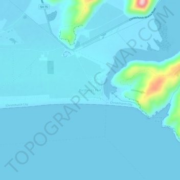
Name: Birdlings Flat topographic map, elevation, terrain.
Average elevation: 49 ft
Minimum elevation: -13 ft
Maximum elevation: 764 ft
Other topographic maps
Click on a map to view its topography, its elevation and its terrain.
Le Bons Bay
New Zealand > Canterbury > Christchurch City > Banks Peninsula Community
Average elevation: 801 ft
Akaroa
New Zealand > Canterbury > Christchurch City > Banks Peninsula Community
Average elevation: 499 ft
Little River
New Zealand > Canterbury > Christchurch City > Banks Peninsula Community
Average elevation: 722 ft
Okains Bay
New Zealand > Canterbury > Christchurch City > Banks Peninsula Community
Average elevation: 486 ft
Wainui
New Zealand > Canterbury > Christchurch City > Banks Peninsula Community
Average elevation: 666 ft
Duvauchelle
New Zealand > Canterbury > Christchurch City > Banks Peninsula Community
Average elevation: 909 ft