
Lincoln topographic map
Click on the map to display elevation.
Lincoln
Lincoln is situated on the Great Plains, characterized by gently rolling terrain that rises from about 1,100 feet above sea level to approximately 1,400 feet in the surrounding areas. The city is primarily composed of prairies and grasslands, interspersed with wooded areas and small hills. The landscape features numerous parks and green spaces, with the Salt Creek running through the region, providing a natural waterway that contributes to the area's biodiversity. This topography offers a scenic backdrop for the city, combining open spaces with urban development, creating a harmonious blend of nature and civilization. The relatively flat terrain makes it suitable for agriculture, contributing to the region's economy while also providing ample opportunities for outdoor recreational activities.
About this map
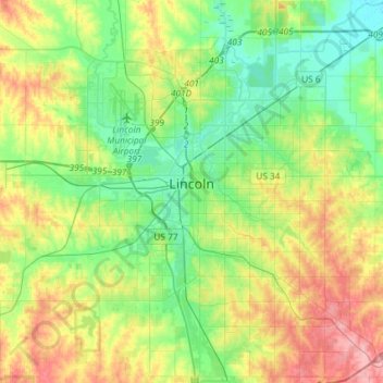
Name: Lincoln topographic map, elevation, terrain.
Location: Lincoln, Lancaster County, Nebraska, United States (40.69377 -96.80415 40.91500 -96.56752)
Average elevation: 1,243 ft
Minimum elevation: 1,115 ft
Maximum elevation: 1,467 ft
Lancaster County trails, hiking, mountain biking, running and outdoor activities
Other topographic maps
Click on a map to view its topography, its elevation and its terrain.