Geolocate

灵山卫街道 topographic map

Interactive map

Click on the map to display elevation.

About this map

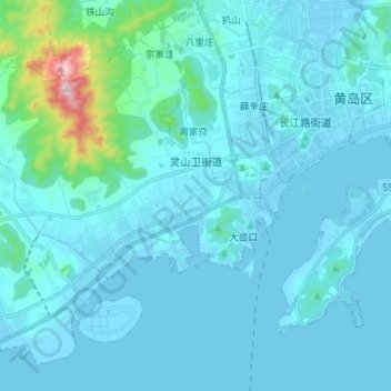
Name: 灵山卫街道 topographic map, elevation, terrain.

Location: 灵山卫街道, 西海岸新区, 黄岛区, 青岛市, 山东省, 266500, 中国 (35.88116 120.02407 35.97938 120.16433)

Average elevation: 177 ft

Minimum elevation: -7 ft

Maximum elevation: 2,251 ft

Other topographic maps

Click on a map to view its topography, its elevation and its terrain.

唐岛湾公园

中国 > 山东省 > 黄岛区

唐岛湾公园, 西海岸新区, 黄岛区, 青岛市, 山东省, 266500, 中国

Average elevation: 13 ft

西华山

中国 > 山东省 > 黄岛区

西华山, 黄岛区, 青岛市, 山东省, 266500, 中国

Average elevation: 138 ft

山东

中国 > 山东省 > 黄岛区 > 山东

山东, 黄岛区, 青岛市, 山东省, 266500, 中国

Average elevation: 56 ft

岔河

中国 > 山东省 > 黄岛区

岔河, 黄岛区, 青岛市, 山东省, 266500, 中国

Average elevation: 79 ft

吉利河

中国 > 山东省 > 黄岛区

吉利河, 黄岛区, 青岛市, 山东省, 266500, 中国

Average elevation: 102 ft