Geolocate

Kearney topographic map

Click on the map to display elevation.

About this map

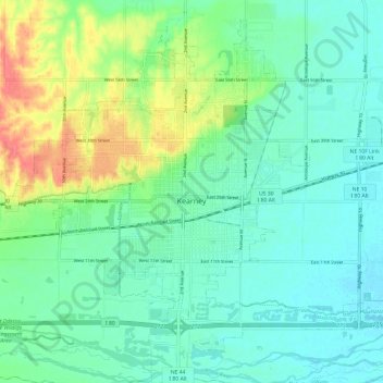
Name: Kearney topographic map, elevation, terrain.

Location: Kearney, Buffalo County, Nebraska, United States (40.65197 -99.13867 40.74271 -99.01811)

Average elevation: 2,172 ft

Minimum elevation: 2,116 ft

Maximum elevation: 2,316 ft

Buffalo County trails, hiking, mountain biking, running and outdoor activities

Other topographic maps

Click on a map to view its topography, its elevation and its terrain.

Glenwood Park

United States > Nebraska > Buffalo County

Average elevation: 2,169 ft

wood

United States > Nebraska > Buffalo County

Average elevation: 2,310 ft

Denman

United States > Nebraska > Buffalo County

Average elevation: 2,018 ft

Denman

United States > Nebraska > Buffalo County

Average elevation: 2,018 ft

Gear up for your next adventure:

🧼Biodegradable Camping Soap - Eco‑friendly soap for outdoor hygiene
🗺️NatGeo Topo Maps - High-quality waterproof printed topographic maps of US Parks
🧥Waterproof Jacket for Hiking - Breathable and rugged rain jacket for outdoor excursions
🧢Outdoor Hiking Hat - Sun protection hat for outdoor explorers
🔥Fast-Boil Camping Stoves - Efficient cooking systems for quick trail meals

As an Amazon Associate, this site earns from qualifying purchases at no extra cost to you.