
Gračišće topographic map
Interactive map
Click on the map to display elevation.
About this map
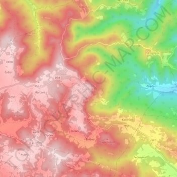
Name: Gračišće topographic map, elevation, terrain.
Location: Gračišće, Općina Gračišće, Istria County, 52403, Croatia (45.19997 13.99012 45.23997 14.03012)
Average elevation: 1,099 ft
Minimum elevation: 315 ft
Maximum elevation: 1,535 ft
The municipality is located in the interior of the Istrian peninsula. The Gračišće village which is also the administrative centre of Gračišće municipality is located about 8 km (5.0 mi) east of the county seat Pazin, on the road to Kršan and Vozilići. It is seated on the top of the hill at an elevation of 457 m (1,499 ft) and has the overall appearance of a typical medieval Istrian town. The village stands completely under monumental protection. The old cemetery which is located in front of St. Vitus Church offers a panoramic view of inner Istria up to the Učka mountain range (1,402 m (4,600 ft)) in the east, as well as to the Julian Alps and the Dolomites in the north.
Other topographic maps
Click on a map to view its topography, its elevation and its terrain.
Bale
Bale, Općina Bale, Istria County, 52211, Croatia
Average elevation: 387 ft
Općina Sveti Petar u Šumi
Općina Sveti Petar u Šumi, Istria County, 52404, Croatia
Average elevation: 1,050 ft
Grobnik
Grobnik, Općina Pićan, Istria County, 52233, Croatia
Average elevation: 440 ft
Rovinj
Croatia > Istria County > Rovinj
Rovinj, Grad Rovinj, Istria County, 52210, Croatia
Average elevation: 62 ft
Općina Tar-Vabriga
Općina Tar-Vabriga, Istria County, Croatia
Average elevation: 43 ft
Uvala Jezero
Croatia > Istria County > Grad Pula
Uvala Jezero, Grad Pula, Istria County, Croatia
Average elevation: 7 ft
Kanfanar
Kanfanar, Općina Kanfanar, Istria County, Croatia
Average elevation: 846 ft
Rabac
Rabac, Grad Labin, Istria County, 52221, Croatia
Average elevation: 502 ft
Belavići
Belavići, Općina Marčana, Istria County, Croatia
Average elevation: 627 ft
Rašpor
Rašpor, Općina Lanišće, Istria County, 52422, Croatia
Average elevation: 2,448 ft