Geolocate

Simeon topographic map

Click on the map to display elevation.

About this map

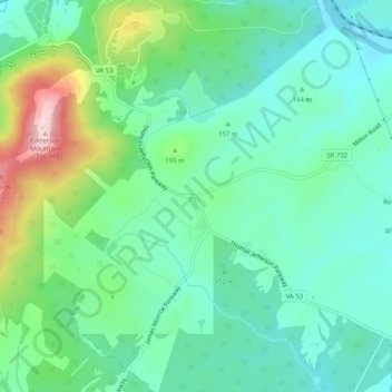
Name: Simeon topographic map, elevation, terrain.

Location: Simeon, Albemarle County, Virginia, 22092, United States (37.98288 -78.45463 38.00288 -78.43463)

Average elevation: 528 ft

Minimum elevation: 351 ft

Maximum elevation: 1,076 ft

Other topographic maps

Click on a map to view its topography, its elevation and its terrain.

Crozet

United States > Virginia > Albemarle County > Crozet

Average elevation: 682 ft

Free Union

United States > Virginia > Albemarle County > Free Union

Average elevation: 518 ft

Keswick

United States > Virginia > Albemarle County > Keswick

Average elevation: 417 ft

Rio

United States > Virginia > Albemarle County > Rio

Average elevation: 489 ft

Scottsville

United States > Virginia > Albemarle County

Average elevation: 377 ft

Ivy

United States > Virginia > Albemarle County

Average elevation: 614 ft

Rio

United States > Virginia > Albemarle County > Rio

Average elevation: 489 ft

Lake

United States > Virginia > Albemarle County > Hollymead

Average elevation: 495 ft

Crozet

United States > Virginia > Albemarle County > Crozet

Average elevation: 682 ft

Gear up for your next adventure:

🥩Freeze-Dried Meals - Nutritious and lightweight food for remote expeditions
📡GPS Antenna Upgrade - Enhance GPS reception in remote terrain
🛡️Insect Repellent - Protection against bugs during outdoor activities
🥾Women's Hiking Boots - Top-rated trail boots with ankle support and superior grip
🧦Hiking Socks - Comfortable socks to prevent blisters on long hikes

As an Amazon Associate, this site earns from qualifying purchases at no extra cost to you.