
Virginia Lake topographic map
Click on the map to display elevation.
About this map
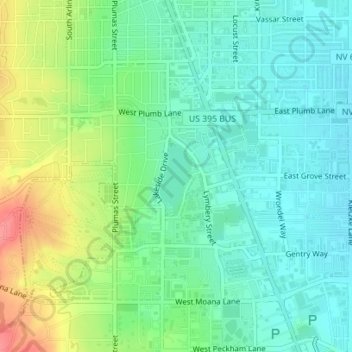
Name: Virginia Lake topographic map, elevation, terrain.
Location: Virginia Lake, Reno, Washoe County, Nevada, United States (39.49784 -119.80835 39.50381 -119.80492)
Average elevation: 4,501 ft
Minimum elevation: 4,423 ft
Maximum elevation: 4,665 ft
Washoe County trails, hiking, mountain biking, running and outdoor activities
Other topographic maps
Click on a map to view its topography, its elevation and its terrain.