
Make a donation
Gear up for your next adventure:
As an Amazon Associate, this site earns from qualifying purchases at no extra cost to you.
Plan topographic map
Click on the map to display elevation.
Make a donation
Gear up for your next adventure:
As an Amazon Associate, this site earns from qualifying purchases at no extra cost to you.
About this map
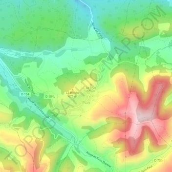
Name: Plan topographic map, elevation, terrain.
Average elevation: 1,870 ft
Minimum elevation: 1,394 ft
Maximum elevation: 2,566 ft
Make a donation
Gear up for your next adventure:
As an Amazon Associate, this site earns from qualifying purchases at no extra cost to you.
Other topographic maps
Click on a map to view its topography, its elevation and its terrain.
Make a donation
Gear up for your next adventure:
As an Amazon Associate, this site earns from qualifying purchases at no extra cost to you.
Make a donation
Gear up for your next adventure:
As an Amazon Associate, this site earns from qualifying purchases at no extra cost to you.
Lac de Paladru
France > Auvergne-Rhône-Alpes > Isère > Paladru
The lake area has a cool temperate climate. The north–south orientation and relatively high altitude means the average temperature is around 10 °C. Rainfall is irregular, with most rain occurring in June and October with the rise of humid air masses from the Mediterranean. January is the coldest month, with…
Average elevation: 1,867 ft
Make a donation
Gear up for your next adventure:
As an Amazon Associate, this site earns from qualifying purchases at no extra cost to you.
Make a donation
Gear up for your next adventure:
As an Amazon Associate, this site earns from qualifying purchases at no extra cost to you.
Les Brunières
France > Auvergne-Rhône-Alpes > Isère > Saint-Quentin-sur-Isère
Average elevation: 1,388 ft
Uriage Les Bains
France > Auvergne-Rhône-Alpes > Isère > Saint-Martin-d'Uriage
Average elevation: 2,028 ft
Make a donation
Gear up for your next adventure:
As an Amazon Associate, this site earns from qualifying purchases at no extra cost to you.
Hameau des Farlaix
France > Auvergne-Rhône-Alpes > Isère > Autrans-Méaudre en Vercors > Méaudre
Average elevation: 3,789 ft
Roche Béranger
France > Auvergne-Rhône-Alpes > Isère > Chamrousse
The road to the ski station starts at Uriage-les-Bains from where the climb is 19 km (12 mi) long, gaining 1,235 m (4,052 ft) in elevation, at an average gradient of 6.5%. There are several sections in excess off 11% in the early stages of the climb. For the Tour de France, the summit is at an elevation of…
Average elevation: 5,121 ft
Make a donation
Gear up for your next adventure:
As an Amazon Associate, this site earns from qualifying purchases at no extra cost to you.
Make a donation
Gear up for your next adventure:
As an Amazon Associate, this site earns from qualifying purchases at no extra cost to you.
Les Bourdoires
France > Auvergne-Rhône-Alpes > Isère > Saint-Laurent-du-Pont
Average elevation: 2,060 ft
Make a donation
Gear up for your next adventure:
As an Amazon Associate, this site earns from qualifying purchases at no extra cost to you.
Make a donation
Gear up for your next adventure:
As an Amazon Associate, this site earns from qualifying purchases at no extra cost to you.
Pic du Lac Blanc
France > Auvergne-Rhône-Alpes > Isère > Le Freney-d'Oisans
Average elevation: 9,554 ft
Make a donation
Gear up for your next adventure:
As an Amazon Associate, this site earns from qualifying purchases at no extra cost to you.