
River Bend topographic map
Interactive map
Click on the map to display elevation.
About this map
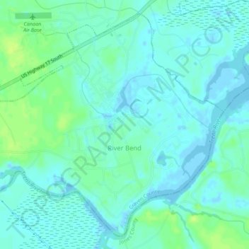
Name: River Bend topographic map, elevation, terrain.
Location: River Bend, Craven County, North Carolina, United States (35.05684 -77.17215 35.08758 -77.13021)
Average elevation: 16 ft
Minimum elevation: -16 ft
Maximum elevation: 46 ft
Craven County trails, hiking, mountain biking, running and outdoor activities
Other topographic maps
Click on a map to view its topography, its elevation and its terrain.
Country Club Park
United States > North Carolina > Craven County > Trent Woods
Average elevation: 16 ft
Southgate
United States > North Carolina > Craven County > New Bern > Southgate
Average elevation: 20 ft
Havelock
United States > North Carolina > Craven County > Havelock > Havelock
Average elevation: 26 ft