
Thank you for supporting this site ❤️
Make a donation
Make a donation
Gear up for your next adventure:
As an Amazon Associate, this site earns from qualifying purchases at no extra cost to you.
Ikaluit topographic map
Click on the map to display elevation.
Thank you for supporting this site ❤️
Make a donation
Make a donation
Gear up for your next adventure:
As an Amazon Associate, this site earns from qualifying purchases at no extra cost to you.
About this map
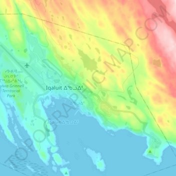
Name: Ikaluit topographic map, elevation, terrain.
Location: Ikaluit, Iqaluit, ᐃᖃᓗᐃᑦ, Qikiqtaaluk Region, Nunavut, Canada (63.72181 -68.57950 63.77627 -68.43337)
Average elevation: 243 ft
Minimum elevation: -3 ft
Maximum elevation: 853 ft
Thank you for supporting this site ❤️
Make a donation
Make a donation
Gear up for your next adventure:
As an Amazon Associate, this site earns from qualifying purchases at no extra cost to you.