
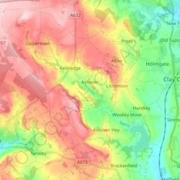
Ashover CP topographic map
Interactive map
Click on the map to display elevation.
About this map
Name: Ashover CP topographic map, elevation, terrain.
Average elevation: 689 ft
Minimum elevation: 299 ft
Maximum elevation: 1,096 ft
By the 18th century, there were several thousand acres of unenclosed moorland in the parish of Ashover, principally covered with heath. The only paths across this wilderness for roads were tracks in the sand or heath with here and there a stone post on the hills or elevations to serve as guides to the traveller and packhorses which traversed one point of the area to another.
Other topographic maps
Click on a map to view its topography, its elevation and its terrain.
Ridgeway
United Kingdom > England > Derbyshire > North East Derbyshire
Ridgeway, North East Derbyshire, Derbyshire, England, S12 3XT, United Kingdom
Average elevation: 446 ft
Killamarsh
United Kingdom > England > Derbyshire > North East Derbyshire
Killamarsh, North East Derbyshire, Derbyshire, England, United Kingdom
Average elevation: 246 ft
Corbriggs
United Kingdom > England > Derbyshire > North East Derbyshire
Corbriggs, North East Derbyshire, Derbyshire, England, S41 0JR, United Kingdom
Average elevation: 374 ft
Middle Handley
United Kingdom > England > Derbyshire > North East Derbyshire
Middle Handley, North East Derbyshire, Derbyshire, England, S21 5RY, United Kingdom
Average elevation: 449 ft
Brackenfield CP
United Kingdom > England > Derbyshire > North East Derbyshire
Brackenfield CP, North East Derbyshire, Derbyshire, England, United Kingdom
Average elevation: 551 ft
Doghole Wood
United Kingdom > England > Derbyshire > North East Derbyshire > Holymoorside
Doghole Wood, Holymoorside and Walton, Holymoorside, North East Derbyshire, Derbyshire, England, United Kingdom
Average elevation: 466 ft
Ashover Hay
United Kingdom > England > Derbyshire > North East Derbyshire
Ashover Hay, North East Derbyshire, Derbyshire, England, S45 0HN, United Kingdom
Average elevation: 650 ft
Kelstedge
United Kingdom > England > Derbyshire > North East Derbyshire
Kelstedge, North East Derbyshire, Derbyshire, England, S45 0DY, United Kingdom
Average elevation: 807 ft
Ogston Reservoir
United Kingdom > England > Derbyshire > North East Derbyshire > Woolley Moor
Ogston Reservoir, Brackenfield CP, Woolley Moor, North East Derbyshire, Derbyshire, England, United Kingdom
Average elevation: 449 ft
Handley
United Kingdom > England > Derbyshire > North East Derbyshire
Handley, North East Derbyshire, Derbyshire, England, S45 9AT, United Kingdom
Average elevation: 515 ft
Sutton Scarsdale
United Kingdom > England > Derbyshire > North East Derbyshire
Sutton Scarsdale, North East Derbyshire, Derbyshire, England, S44 5UT, United Kingdom
Average elevation: 358 ft
Shirland
United Kingdom > England > Derbyshire > North East Derbyshire
Shirland, North East Derbyshire, Derbyshire, England, DE55 6BX, United Kingdom
Average elevation: 397 ft
Wingerworth
United Kingdom > England > Derbyshire > North East Derbyshire
Wingerworth, North East Derbyshire, Derbyshire, England, United Kingdom
Average elevation: 489 ft
Barlow
United Kingdom > England > Derbyshire > North East Derbyshire > Barlow
Barlow, North East Derbyshire, Derbyshire, England, United Kingdom
Average elevation: 535 ft
Cartledge
United Kingdom > England > Derbyshire > North East Derbyshire > Holmesfield > Cartledge
Cartledge, Holmesfield, North East Derbyshire, Derbyshire, England, S18 7SB, United Kingdom
Average elevation: 630 ft
Holmesfield
United Kingdom > England > Derbyshire > North East Derbyshire > Holmesfield
Holmesfield, North East Derbyshire, Derbyshire, England, United Kingdom
Average elevation: 764 ft
Troway
United Kingdom > England > Derbyshire > North East Derbyshire > Eckington > Troway
Troway, Eckington, North East Derbyshire, Derbyshire, East Midlands, England, S21 5RT, United Kingdom
Average elevation: 515 ft
Dronfield
United Kingdom > England > Derbyshire > North East Derbyshire
Dronfield, North East Derbyshire, Derbyshire, England, United Kingdom
Average elevation: 548 ft
Millthorpe
United Kingdom > England > Derbyshire > North East Derbyshire > Holmesfield > Millthorpe
Millthorpe, Holmesfield, North East Derbyshire, Derbyshire, East Midlands, England, S18 7WJ, United Kingdom
Average elevation: 692 ft
North Wingfield
United Kingdom > England > Derbyshire > North East Derbyshire
North Wingfield, North East Derbyshire, Derbyshire, England, United Kingdom
Average elevation: 413 ft
Wadshelf
United Kingdom > England > Derbyshire > North East Derbyshire
Wadshelf, North East Derbyshire, Derbyshire, England, S42 7BY, United Kingdom
Average elevation: 833 ft
Tupton
United Kingdom > England > Derbyshire > North East Derbyshire
Tupton, North East Derbyshire, Derbyshire, England, United Kingdom
Average elevation: 394 ft
Winsick
United Kingdom > England > Derbyshire > North East Derbyshire
Winsick, North East Derbyshire, Derbyshire, England, S41 0JH, United Kingdom
Average elevation: 361 ft
Unstone
United Kingdom > England > Derbyshire > North East Derbyshire
Unstone, North East Derbyshire, Derbyshire, England, United Kingdom
Average elevation: 479 ft
Unstone Green
United Kingdom > England > Derbyshire > North East Derbyshire > Unstone Green
Unstone Green, North East Derbyshire, Derbyshire, East Midlands, England, S18 4DB, United Kingdom
Average elevation: 449 ft
Holymoorside
United Kingdom > England > Derbyshire > North East Derbyshire
Holymoorside, North East Derbyshire, Derbyshire, England, S42 7HB, United Kingdom
Average elevation: 653 ft
Calow
United Kingdom > England > Derbyshire > North East Derbyshire
Calow, North East Derbyshire, Derbyshire, England, United Kingdom
Average elevation: 384 ft
Clay Cross CP
United Kingdom > England > Derbyshire > North East Derbyshire
Clay Cross CP, North East Derbyshire, Derbyshire, England, United Kingdom
Average elevation: 436 ft
Old Brampton
United Kingdom > England > Derbyshire > North East Derbyshire > Old Brampton
Old Brampton, North East Derbyshire, Derbyshire, England, S42 7JG, United Kingdom
Average elevation: 594 ft
Grassmoor
United Kingdom > England > Derbyshire > North East Derbyshire > Grassmoor
Grassmoor, North East Derbyshire, Derbyshire, East Midlands, England, S42 5ER, United Kingdom
Average elevation: 387 ft
Eckington
United Kingdom > England > Derbyshire > North East Derbyshire
Eckington, North East Derbyshire, Derbyshire, England, United Kingdom
Average elevation: 338 ft
Pilsley
United Kingdom > England > Derbyshire > North East Derbyshire
Pilsley, North East Derbyshire, Derbyshire, England, United Kingdom
Average elevation: 459 ft
Temple Normanton
United Kingdom > England > Derbyshire > North East Derbyshire
Temple Normanton, North East Derbyshire, Derbyshire, England, United Kingdom
Average elevation: 400 ft
Marsh Lane
United Kingdom > England > Derbyshire > North East Derbyshire
Marsh Lane, North East Derbyshire, Derbyshire, England, S21 5RS, United Kingdom
Average elevation: 446 ft