Geolocate

Wilsonville topographic map

Interactive map

Click on the map to display elevation.

About this map

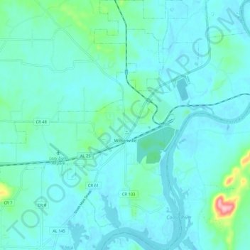
Name: Wilsonville topographic map, elevation, terrain.

Location: Wilsonville, Shelby County, Alabama, United States (33.19086 -86.53577 33.28422 -86.45717)

Average elevation: 459 ft

Minimum elevation: 394 ft

Maximum elevation: 886 ft

Shelby County trails, hiking, mountain biking, running and outdoor activities

Other topographic maps

Click on a map to view its topography, its elevation and its terrain.

Valley Forge

United States > Alabama > Shelby County > Alabaster

Average elevation: 499 ft

Scottsdale

United States > Alabama > Shelby County > Alabaster

Average elevation: 551 ft

Lake Purdy

United States > Alabama > Shelby County > Brook Highland

Average elevation: 614 ft

Westover

United States > Alabama > Shelby County

Average elevation: 502 ft

Hardy

United States > Alabama > Shelby County > Alabaster

Average elevation: 515 ft

Meadowbrook

United States > Alabama > Shelby County > Meadowbrook

Average elevation: 630 ft

Ozan

United States > Alabama > Shelby County > Ozan

Average elevation: 551 ft