
Make a donation
Gear up for your next adventure:
As an Amazon Associate, this site earns from qualifying purchases at no extra cost to you.
Corfu topographic map
Click on the map to display elevation.
Make a donation
Gear up for your next adventure:
As an Amazon Associate, this site earns from qualifying purchases at no extra cost to you.
About this map
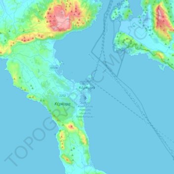
Name: Corfu topographic map, elevation, terrain.
Average elevation: 217 ft
Minimum elevation: -23 ft
Maximum elevation: 2,933 ft
Make a donation
Gear up for your next adventure:
As an Amazon Associate, this site earns from qualifying purchases at no extra cost to you.
Other topographic maps
Click on a map to view its topography, its elevation and its terrain.
Corfu
Greece > Ioanian Islands > Corfu Regional Unit
Two high and well-defined ranges divide the island into three districts, of which the northern is mountainous, the central undulating, and the southern low-lying. The more important of the two ranges, that of Pantokrator (Παντοκράτωρ – the Almighty) stretches east and west from Cape Falacro to…
Average elevation: 135 ft
Agni Beach
Greece > Ioanian Islands > Corfu Regional Unit > Kassopaia Municipal Unit > Kentroma > Agni
Average elevation: 253 ft
Corfu
Greece > Ioanian Islands > Corfu Regional Unit
Two high, well-defined ranges divide the island into three districts: the northern is mountainous, the central undulating, and the southern low-lying. The more important of the two ranges, that of Pantokrator (Παντοκράτωρ – the Almighty) stretches east and west from Cape Falacro to Cape Psaromita,…
Average elevation: 135 ft
Corfu
Greece > Ioanian Islands > Corfu Regional Unit
Two high and well-defined ranges divide the island into three districts, of which the northern is mountainous, the central undulating, and the southern low-lying. The more important of the two ranges, that of Pantokrator (Παντοκράτωρ – the Almighty) stretches east and west from Cape Falacro to…
Average elevation: 135 ft
Make a donation
Gear up for your next adventure:
As an Amazon Associate, this site earns from qualifying purchases at no extra cost to you.
Othonoi
Greece > Ioanian Islands > Corfu Regional Unit > Othonoi Municipal Unit
At the beginning of the second millennium, the island was conquered alternatively by the Franks (the 11th century) and the Venetians (12th century), and often attacked by pirates of Barbary and Algeria. From the end of 1383 until 1386 the domination of Corfu was held by Charles III of Naples. In a letter from…
Average elevation: 161 ft