Geolocate

Carabamba topographic map

Click on the map to display elevation.

About this map

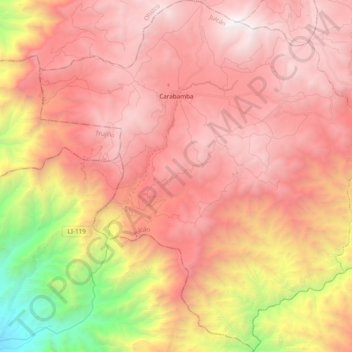
Name: Carabamba topographic map, elevation, terrain.

Location: Carabamba, Province of Julcán, La Libertad, Peru (-8.25103 -78.68243 -8.06102 -78.50003)

Average elevation: 9,331 ft

Minimum elevation: 2,438 ft

Maximum elevation: 13,501 ft

Other topographic maps

Click on a map to view its topography, its elevation and its terrain.

El Paraíso

Peru > La Libertad > Rázuri

Average elevation: 72 ft

Abdon

Peru > La Libertad > Longotea

Average elevation: 9,577 ft

Curva de Sun

Peru > La Libertad > Curva de Sun

Average elevation: 52 ft

Gear up for your next adventure:

🔭Stargazing Telescopes - Perfect for camping in low-light pollution areas shown on maps
🪶Camping Sleeping Pad - Comfortable sleeping pad for backpacking
🔭Telescopic Hiking Pole - Adjustable pole for hiking stability
🪄Magnetic Compass - Accurate compass for navigation
🧦Merino Wool Socks - Moisture-wicking, blister-preventing socks for long treks

As an Amazon Associate, this site earns from qualifying purchases at no extra cost to you.