
Antsla vald topographic map
Interactive map
Click on the map to display elevation.
About this map
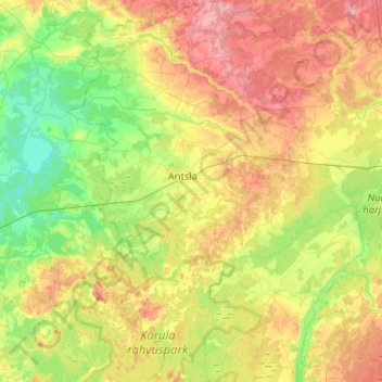
Name: Antsla vald topographic map, elevation, terrain.
Location: Antsla vald, Kreis Werro, Estland (57.67908 26.37095 57.95675 26.77602)
Average elevation: 282 ft
Minimum elevation: 118 ft
Maximum elevation: 528 ft
Other topographic maps
Click on a map to view its topography, its elevation and its terrain.