Geolocate

Houston topographic map

Click on the map to display elevation.

About this map

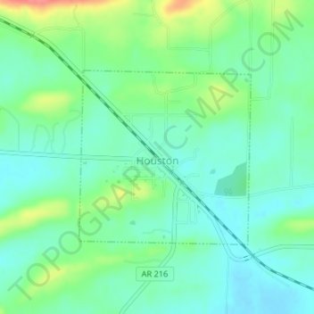
Name: Houston topographic map, elevation, terrain.

Location: Houston, Perry County, Arkansas, 72070, United States (35.02745 -92.70362 35.04243 -92.68558)

Average elevation: 331 ft

Minimum elevation: 262 ft

Maximum elevation: 492 ft

Perry County trails, hiking, mountain biking, running and outdoor activities

Other topographic maps

Click on a map to view its topography, its elevation and its terrain.

Toad Suck

United States > Arkansas > Perry County

Average elevation: 305 ft

Casa

United States > Arkansas > Perry County

Average elevation: 400 ft

Hollis

United States > Arkansas > Perry County > Hollis

Average elevation: 650 ft

Gear up for your next adventure:

🧭Outdoor Navigation Book - Learn advanced navigation skills
🪵Folding Camp Saw - Compact saw for wood and campsite work
🧭Orienteering Set - Complete compass and map reading kit
🪶Camp Gear Gift Set - Perfect gift bundle for outdoor fans
📌Outdoor GPS Map App - Apps and devices for digital topographic navigation

As an Amazon Associate, this site earns from qualifying purchases at no extra cost to you.