
Guadalupe Peak topographic map
Interactive map
Click on the map to display elevation.
Guadalupe Peak
Guadalupe Peak, also known as Signal Peak, is the highest natural point in Texas, with an elevation of 8,751 feet (2,667 m) above sea level. It is located in Guadalupe Mountains National Park, and is part of the Guadalupe Mountains range in southeastern New Mexico and West Texas. The mountain is about 90 miles (140 km) east of El Paso and about 50 miles (80 km) southwest of Carlsbad, New Mexico. The peak rises more than 3,000 feet (910 m) above the arid floor of the Chihuahuan Desert.
About this map
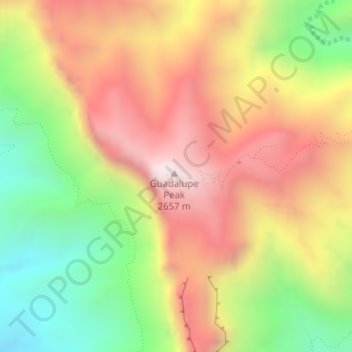
Name: Guadalupe Peak topographic map, elevation, terrain.
Average elevation: 7,054 ft
Minimum elevation: 5,338 ft
Maximum elevation: 8,698 ft
Culberson County trails, hiking, mountain biking, running and outdoor activities
Other topographic maps
Click on a map to view its topography, its elevation and its terrain.
Guadalupe Mountains National Park
United States > Texas > Culberson County
The Guadalupe Mountains reach their highest point at Guadalupe Peak, the highest point in Texas, with an elevation of 8,751 feet (2,667 m). The range lies southeast of the Sacramento Mountains and east of the Brokeoff Mountains. The mountain range extends north-northwest and northeast from Guadalupe Peak in…
Average elevation: 4,869 ft
Van Horn
United States > Texas > Culberson County
According to the United States Census Bureau, the town has a total area of 2.8 square miles (7.3 km2), all land. Threemile Peak, elevation 4,868 feet (1,484 m), rises to the northwest overlooking the town.
Average elevation: 4,075 ft