
Make a donation
Gear up for your next adventure:
As an Amazon Associate, this site earns from qualifying purchases at no extra cost to you.
Van Horn topographic map
Click on the map to display elevation.
Make a donation
Gear up for your next adventure:
As an Amazon Associate, this site earns from qualifying purchases at no extra cost to you.
Van Horn
According to the United States Census Bureau, the town has a total area of 2.8 square miles (7.3 km2), all land. Threemile Peak, elevation 4,868 feet (1,484 m), rises to the northwest overlooking the town.
Make a donation
Gear up for your next adventure:
As an Amazon Associate, this site earns from qualifying purchases at no extra cost to you.
About this map
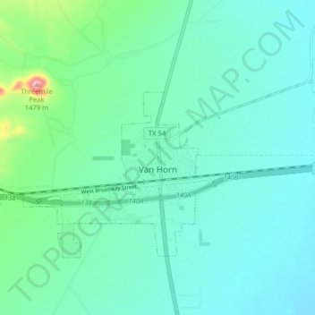
Name: Van Horn topographic map, elevation, terrain.
Location: Van Horn, Culberson County, Texas, 79855, United States (31.02326 -104.86794 31.06712 -104.78595)
Average elevation: 4,075 ft
Minimum elevation: 3,914 ft
Maximum elevation: 4,852 ft
Culberson County trails, hiking, mountain biking, running and outdoor activities
Make a donation
Gear up for your next adventure:
As an Amazon Associate, this site earns from qualifying purchases at no extra cost to you.
Other topographic maps
Click on a map to view its topography, its elevation and its terrain.
Guadalupe Peak
United States > Texas > Culberson County
Guadalupe Peak, also known as Signal Peak, is the highest natural point in Texas, with an elevation of 8,751 feet (2,667 m) above sea level. It is located in Guadalupe Mountains National Park, and is part of the Guadalupe Mountains range in southeastern New Mexico and West Texas. The mountain is about 90 miles…
Average elevation: 7,054 ft