
Make a donation
Gear up for your next adventure:
As an Amazon Associate, this site earns from qualifying purchases at no extra cost to you.
Bridgewater Township topographic map
Click on the map to display elevation.
Make a donation
Gear up for your next adventure:
As an Amazon Associate, this site earns from qualifying purchases at no extra cost to you.
About this map
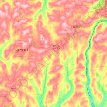
Name: Bridgewater Township topographic map, elevation, terrain.
Average elevation: 1,519 ft
Minimum elevation: 961 ft
Maximum elevation: 1,873 ft
Susquehanna County trails, hiking, mountain biking, running and outdoor activities
Make a donation
Gear up for your next adventure:
As an Amazon Associate, this site earns from qualifying purchases at no extra cost to you.
Other topographic maps
Click on a map to view its topography, its elevation and its terrain.
Stevens Point
United States > Pennsylvania > Susquehanna County > Harmony Township
Average elevation: 1,424 ft
Brackney
United States > Pennsylvania > Susquehanna County > Silver Lake Township
Average elevation: 1,611 ft
Jackson
United States > Pennsylvania > Susquehanna County > Jackson Township
Average elevation: 1,578 ft
Make a donation
Gear up for your next adventure:
As an Amazon Associate, this site earns from qualifying purchases at no extra cost to you.
Springville
United States > Pennsylvania > Susquehanna County > Springville Township
Average elevation: 1,276 ft
Elkdale
United States > Pennsylvania > Susquehanna County > Clifford Township
Average elevation: 1,519 ft
Woodhouse
United States > Pennsylvania > Susquehanna County > Dimock Township
Average elevation: 1,365 ft
Make a donation
Gear up for your next adventure:
As an Amazon Associate, this site earns from qualifying purchases at no extra cost to you.
Lakeside
United States > Pennsylvania > Susquehanna County > New Milford Township
Average elevation: 1,568 ft
Make a donation
Gear up for your next adventure:
As an Amazon Associate, this site earns from qualifying purchases at no extra cost to you.
Fiddle Lake
United States > Pennsylvania > Susquehanna County > Ararat Township
Average elevation: 1,998 ft
Forest Lake
United States > Pennsylvania > Susquehanna County > Forest Lake
Average elevation: 1,631 ft
Make a donation
Gear up for your next adventure:
As an Amazon Associate, this site earns from qualifying purchases at no extra cost to you.
Smokey Mountain
United States > Pennsylvania > Susquehanna County > Great Bend Township
Average elevation: 1,178 ft