
Make a donation
Gear up for your next adventure:
As an Amazon Associate, this site earns from qualifying purchases at no extra cost to you.
Hohenpeißenberg topographic map
Click on the map to display elevation.
Make a donation
Gear up for your next adventure:
As an Amazon Associate, this site earns from qualifying purchases at no extra cost to you.
Hohenpeißenberg
The climate is oceanic (Köppen: Cfb), affected by altitude and proximity to the Alps (especially in precipitation). Registering data continuously since 1781, the Hohenpeißenberg Observatory is the oldest in the world located on a mountain. The station located in the alpine foothills integrates the German Meteorological Network and served for the program Global Atmospheric Watch program (GAW).
Make a donation
Gear up for your next adventure:
As an Amazon Associate, this site earns from qualifying purchases at no extra cost to you.
About this map
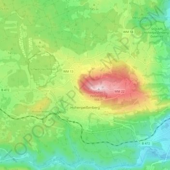
Name: Hohenpeißenberg topographic map, elevation, terrain.
Average elevation: 2,402 ft
Minimum elevation: 1,942 ft
Maximum elevation: 3,235 ft
Make a donation
Gear up for your next adventure:
As an Amazon Associate, this site earns from qualifying purchases at no extra cost to you.
Other topographic maps
Click on a map to view its topography, its elevation and its terrain.
Make a donation
Gear up for your next adventure:
As an Amazon Associate, this site earns from qualifying purchases at no extra cost to you.
Schwabsoien
Germany > Bavaria > Landkreis Weilheim-Schongau > Schwabsoien > Schwabsoien
Average elevation: 2,503 ft