Geolocate

Harrod topographic map

Click on the map to display elevation.

About this map

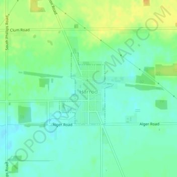
Name: Harrod topographic map, elevation, terrain.

Location: Harrod, Allen County, Ohio, United States (40.70277 -83.92696 40.71370 -83.91616)

Average elevation: 1,001 ft

Minimum elevation: 965 ft

Maximum elevation: 1,056 ft

Allen County trails, hiking, mountain biking, running and outdoor activities

Other topographic maps

Click on a map to view its topography, its elevation and its terrain.

Lima

United States > Ohio > Allen County

Average elevation: 876 ft

Gomer

United States > Ohio > Allen County

Average elevation: 778 ft

Westminster

United States > Ohio > Allen County

Average elevation: 965 ft

Allentown

United States > Ohio > Allen County > Lima

Average elevation: 820 ft

Conant

United States > Ohio > Allen County

Average elevation: 823 ft

Hume

United States > Ohio > Allen County

Average elevation: 853 ft

Kemp

United States > Ohio > Allen County

Average elevation: 840 ft

Landeck

United States > Ohio > Allen County

Average elevation: 794 ft

Maysville

United States > Ohio > Allen County

Average elevation: 1,007 ft

Rockport

United States > Ohio > Allen County

Average elevation: 814 ft

Scotts Crossing

United States > Ohio > Allen County

Average elevation: 784 ft

South Warsaw

United States > Ohio > Allen County

Average elevation: 928 ft

Southworth

United States > Ohio > Allen County

Average elevation: 810 ft

West Newton

United States > Ohio > Allen County

Average elevation: 1,037 ft

Gear up for your next adventure:

🕶️GPS Smartphone Mount - Secure mount for phone navigation
GPS Sports Watch - GPS watch for running, hiking and training
🪶Camp Gear Gift Set - Perfect gift bundle for outdoor fans
🩹Survival Bandages - High‑quality bandages for emergencies
🥇GPS Hiking Watch - Multi‑sport GPS watch with navigation and trail tracking

As an Amazon Associate, this site earns from qualifying purchases at no extra cost to you.