
Cap Saint-Jacques topographic map
Click on the map to display elevation.
About this map
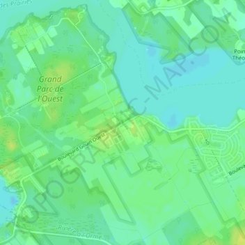
Name: Cap Saint-Jacques topographic map, elevation, terrain.
Average elevation: 82 ft
Minimum elevation: 59 ft
Maximum elevation: 115 ft
Other topographic maps
Click on a map to view its topography, its elevation and its terrain.
Rivière des Prairies
Canada > Quebec > Urban agglomeration of Montreal > Montreal
Average elevation: 112 ft
Parc de la Rive-Boisée
Canada > Quebec > Urban agglomeration of Montreal > Montreal
Average elevation: 95 ft
Rivière des Prairies
Canada > Quebec > Urban agglomeration of Montreal > Montreal
Average elevation: 118 ft
Notre Dame Island
Canada > Quebec > Urban agglomeration of Montreal > Montreal
Average elevation: 46 ft
Rosemont–La Petite-Patrie
Canada > Quebec > Urban agglomeration of Montreal > Montreal
Average elevation: 164 ft
Pierrefonds-Roxboro
Canada > Quebec > Urban agglomeration of Montreal > Montreal
Average elevation: 98 ft
Parc Léon-Provancher
Canada > Quebec > Urban agglomeration of Montreal > Montreal
Average elevation: 174 ft
Saint Helen's Island
Canada > Quebec > Urban agglomeration of Montreal > Montreal
Average elevation: 49 ft
Le Plateau-Mont-Royal
Canada > Quebec > Urban agglomeration of Montreal > Montreal
Average elevation: 230 ft
Parc-nature du Bois-de-Liesse
Canada > Quebec > Urban agglomeration of Montreal > Montreal
Average elevation: 92 ft
Parc-nature de la Pointe-aux-Prairies
Canada > Quebec > Urban agglomeration of Montreal > Montreal
Average elevation: 39 ft
Victoria Square
Canada > Quebec > Urban agglomeration of Montreal > Montreal
Average elevation: 102 ft
Victoria Square
Canada > Quebec > Urban agglomeration of Montreal > Montreal
Average elevation: 102 ft