Geolocate

Lower Subansiri topographic map

Click on the map to display elevation.

About this map

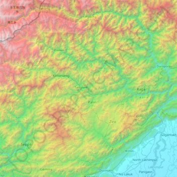
Name: Lower Subansiri topographic map, elevation, terrain.

Location: Lower Subansiri, Kra Daadi, Arunachal Pradesh, India (27.10000 92.90000 28.50000 94.30000)

Average elevation: 5,804 ft

Minimum elevation: 262 ft

Maximum elevation: 20,919 ft

Other topographic maps

Click on a map to view its topography, its elevation and its terrain.

Dirang ADC

India > Arunachal Pradesh

Average elevation: 10,472 ft

Papum Pare

India > Arunachal Pradesh

Average elevation: 3,556 ft

Pakke Kessang

India > Arunachal Pradesh

Average elevation: 3,186 ft

Namsai

India > Arunachal Pradesh

Average elevation: 725 ft

Tali

India > Arunachal Pradesh > Tali ADC

Average elevation: 3,615 ft

Dibang Valley district

India > Arunachal Pradesh

Average elevation: 10,052 ft

Namdapha

India > Arunachal Pradesh > Miao ADC

Average elevation: 6,519 ft

Tinali Paglam Circle

India > Arunachal Pradesh

Average elevation: 492 ft

Dollungmukh Circle

India > Arunachal Pradesh

Average elevation: 3,422 ft

Nyapin

India > Arunachal Pradesh > Nyapin ADC

Average elevation: 3,973 ft

Sangram

India > Arunachal Pradesh > Sangram SDO

Average elevation: 3,117 ft

Ruksin ADC

India > Arunachal Pradesh

Average elevation: 650 ft

Gear up for your next adventure:

🧣Hiking Neck Gaiter - Multi‑use neck protection for outdoor weather
🧭Outdoor Navigation Book - Learn advanced navigation skills
🪶Fire Starter Kit - Reliable fire starter for survival and camping
🚗GPS Dash Cams - Record your scenic drives through mountain passes and canyons
🗺️Topographic Maps - Detailed topo maps for hiking, exploring and outdoor navigation

As an Amazon Associate, this site earns from qualifying purchases at no extra cost to you.