
Make a donation
Gear up for your next adventure:
As an Amazon Associate, this site earns from qualifying purchases at no extra cost to you.
Namsai topographic map
Click on the map to display elevation.
Make a donation
Gear up for your next adventure:
As an Amazon Associate, this site earns from qualifying purchases at no extra cost to you.
About this map
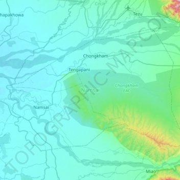
Name: Namsai topographic map, elevation, terrain.
Location: Namsai, Arunachal Pradesh, India (27.54351 95.75212 27.88400 96.31740)
Average elevation: 725 ft
Minimum elevation: 420 ft
Maximum elevation: 4,839 ft
Make a donation
Gear up for your next adventure:
As an Amazon Associate, this site earns from qualifying purchases at no extra cost to you.
Other topographic maps
Click on a map to view its topography, its elevation and its terrain.
Pasighat
India > Arunachal Pradesh > Pasighat HQ
Pasighat is located at 28°04′N 95°20′E / 28.07°N 95.33°E / 28.07; 95.33. It has an average elevation of 153 metres or 502 feet. Pasighat has a typical lowland Northeast India humid subtropical climate (Köppen Cwa) a little too cool to qualify as a tropical monsoon climate (Am).
Average elevation: 587 ft
Make a donation
Gear up for your next adventure:
As an Amazon Associate, this site earns from qualifying purchases at no extra cost to you.
Make a donation
Gear up for your next adventure:
As an Amazon Associate, this site earns from qualifying purchases at no extra cost to you.
Basar
India > Arunachal Pradesh > Basar ADC
Basar is located at 27°59′N 94°40′E / 27.983°N 94.667°E / 27.983; 94.667. It has an average elevation of 578 meters above mean sea level and has pleasantly cold weather.
Average elevation: 2,510 ft
Hawai
India > Arunachal Pradesh > Hawai HQ
It is located at an altitude of 1296 m above sea level on the banks of the Lohit River, a tributary of the Brahmaputra River.
Average elevation: 7,979 ft
Make a donation
Gear up for your next adventure:
As an Amazon Associate, this site earns from qualifying purchases at no extra cost to you.
Make a donation
Gear up for your next adventure:
As an Amazon Associate, this site earns from qualifying purchases at no extra cost to you.
Make a donation
Gear up for your next adventure:
As an Amazon Associate, this site earns from qualifying purchases at no extra cost to you.
Daporijo
India > Arunachal Pradesh > Daporijo Hq
Daporijo is located at an elevation of 600 m above sea level. It is located beside the river Subansiri, one of the principal rivers of Arunachal Pradesh, and a major tributary of the mighty Brahmaputra Daporijo valley is surrounded by Evergreen hills in three corners and Subansiri river in the other.
Average elevation: 1,775 ft
Make a donation
Gear up for your next adventure:
As an Amazon Associate, this site earns from qualifying purchases at no extra cost to you.
Make a donation
Gear up for your next adventure:
As an Amazon Associate, this site earns from qualifying purchases at no extra cost to you.
Make a donation
Gear up for your next adventure:
As an Amazon Associate, this site earns from qualifying purchases at no extra cost to you.
Make a donation
Gear up for your next adventure:
As an Amazon Associate, this site earns from qualifying purchases at no extra cost to you.
Koloriang
India > Arunachal Pradesh > Koloriang HQ
Koloriang is a hilly district headquarters town of Kurung Kumey district in Arunachal Pradesh, India, bordering Tibet. It has an altitude of 1,000 metres (3,300 ft) and is surrounded by high mountains all around and is located in the right bank of river Kurung, one of the major tributaries of Subansiri river.…
Average elevation: 5,876 ft
Make a donation
Gear up for your next adventure:
As an Amazon Associate, this site earns from qualifying purchases at no extra cost to you.
Make a donation
Gear up for your next adventure:
As an Amazon Associate, this site earns from qualifying purchases at no extra cost to you.
Make a donation
Gear up for your next adventure:
As an Amazon Associate, this site earns from qualifying purchases at no extra cost to you.
Anini
India > Arunachal Pradesh > Anini Circle
The small settlement of Anini is located at an elevation of 1,968 metres (6,457 ft) above sea level. On the Aninese Plateau, the average elevation is 1,800 meters, but the average elevation of the town is 2,068 meters. According to Google Maps' terrain feature, Anini is around 1,600–1,800 meters above sea…
Average elevation: 5,446 ft