Geolocate

Caprauna topographic map

Click on the map to display elevation.

About this map

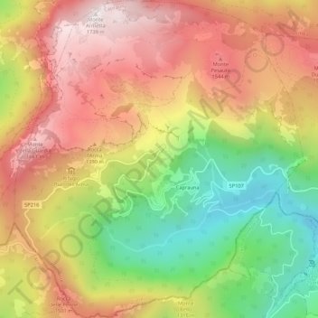
Name: Caprauna topographic map, elevation, terrain.

Location: Caprauna, Cuneo, Piedmont, Italy (44.10032 7.92602 44.13843 7.97429)

Average elevation: 4,026 ft

Minimum elevation: 2,178 ft

Maximum elevation: 5,676 ft

Other topographic maps

Click on a map to view its topography, its elevation and its terrain.

Bertolini

Italy > Piedmont > Cuneo > Crissolo

Average elevation: 5,531 ft

Montescotto

Italy > Piedmont > Cuneo > Barge

Average elevation: 2,110 ft

Monastero

Italy > Piedmont > Cuneo > Mondovì

Average elevation: 1,470 ft

Pievetta

Italy > Piedmont > Cuneo

Average elevation: 2,411 ft

Pianche

Italy > Piedmont > Cuneo

Average elevation: 4,908 ft

San Bernolfo

Italy > Piedmont > Cuneo > Vinadio

Average elevation: 6,680 ft

Gear up for your next adventure:

🥾Women's Hiking Boots - Top-rated trail boots with ankle support and superior grip
🗺️Topographic Maps - Detailed topo maps for hiking, exploring and outdoor navigation
🎁Geography Themed Gifts - Unique gift ideas for map lovers and geography enthusiasts
🧤Tactile Hiking Gloves - Keep hands warm while operating GPS and smartphone screens
🧷Carabiner Set - Durable clips for gear attachment

As an Amazon Associate, this site earns from qualifying purchases at no extra cost to you.