Geolocate

Golden Lake topographic map

Click on the map to display elevation.

About this map

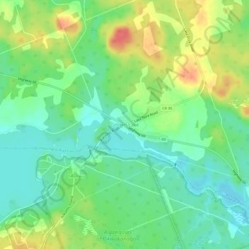
Name: Golden Lake topographic map, elevation, terrain.

Location: Golden Lake, North Algona Wilberforce, Renfrew County, Eastern Ontario, Ontario, K0J 1X0, Canada (45.56088 -77.26468 45.60088 -77.22468)

Average elevation: 607 ft

Minimum elevation: 535 ft

Maximum elevation: 725 ft

Other topographic maps

Click on a map to view its topography, its elevation and its terrain.

Gear up for your next adventure:

🧷Carabiner Set - Durable clips for gear attachment
🖼️Topo Map Wall Art - Decorative topographic prints of famous peaks and regions
🛰️Satellite Messengers - Emergency SOS and two-way messaging for off-grid adventures
🥤Water Filter Bottle - All‑in‑one filter bottle for safe hydration
🔦LED Headlamp - Bright and durable LED headlamp for night navigation

As an Amazon Associate, this site earns from qualifying purchases at no extra cost to you.