Geolocate

Brighton topographic map

Click on the map to display elevation.

About this map

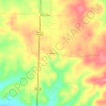
Name: Brighton topographic map, elevation, terrain.

Location: Brighton, Polk County, Missouri, 65617, United States (37.43782 -93.36797 37.47782 -93.32797)

Average elevation: 1,148 ft

Minimum elevation: 971 ft

Maximum elevation: 1,273 ft

Polk County trails, hiking, mountain biking, running and outdoor activities

Other topographic maps

Click on a map to view its topography, its elevation and its terrain.

Pleasant Hope

United States > Missouri > Polk County

Average elevation: 1,145 ft

Humansville

United States > Missouri > Polk County

Average elevation: 965 ft

Bolivar

United States > Missouri > Polk County

Average elevation: 1,096 ft

Bolivar

United States > Missouri > Polk County

Average elevation: 1,096 ft

Goodnight

United States > Missouri > Polk County

Average elevation: 1,093 ft

Gear up for your next adventure:

🚁Photography Drones - Capture stunning aerial views of landforms and topography
Camping Coffee Makers - Enjoy premium coffee at the summit or campsite
📶Satellite Messenger - Communication device off‑grid
🛰️Handheld GPS Units - Professional satellite navigators for precise backcountry mapping
🌎3D Topographic Globes - Raised relief globes for a tactile understanding of geography

As an Amazon Associate, this site earns from qualifying purchases at no extra cost to you.