
Calape topographic map
Click on the map to display elevation.
Calape
Most of the coastal area is a fairly level plain that gradually rises into rolling hills of coralline limestone. The highest point in Calape is Mount Candungao in the eastern portion of the town, with an elevation of 150 metres (500 ft) above sea level.
About this map
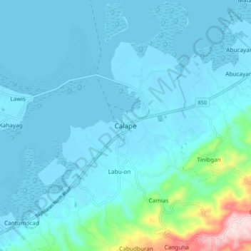
Name: Calape topographic map, elevation, terrain.
Location: Calape, Bohol, Central Visayas, 6328, Philippines (9.85051 123.83187 9.93051 123.91187)
Average elevation: 151 ft
Minimum elevation: -20 ft
Maximum elevation: 1,365 ft
Other topographic maps
Click on a map to view its topography, its elevation and its terrain.