Geolocate

Bryant topographic map

Click on the map to display elevation.

About this map

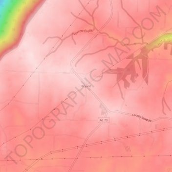
Name: Bryant topographic map, elevation, terrain.

Location: Bryant, Jackson County, Alabama, 35958, United States (34.92369 -85.65219 34.96369 -85.61219)

Average elevation: 1,535 ft

Minimum elevation: 745 ft

Maximum elevation: 1,686 ft

Jackson County trails, hiking, mountain biking, running and outdoor activities

Other topographic maps

Click on a map to view its topography, its elevation and its terrain.

Skyline

United States > Alabama > Jackson County

Average elevation: 1,276 ft

Langston

United States > Alabama > Jackson County

Average elevation: 797 ft

Paint Rock

United States > Alabama > Jackson County

Average elevation: 810 ft

Pleasant Groves

United States > Alabama > Jackson County

Average elevation: 1,086 ft

Hytop

United States > Alabama > Jackson County

Average elevation: 1,355 ft

Dutton

United States > Alabama > Jackson County

Average elevation: 1,345 ft

Scottsboro

United States > Alabama > Jackson County

Average elevation: 771 ft

Stevenson

United States > Alabama > Jackson County

Average elevation: 810 ft

Paint Rock

United States > Alabama > Jackson County

Average elevation: 817 ft

Pisgah

United States > Alabama > Jackson County > Pisgah

Average elevation: 1,375 ft

Gear up for your next adventure:

🌡️Portable Weather Meter - Track weather conditions on the trail
🕶️Glacier Sunglasses - Side shields to protect eyes from high-altitude snow glare
🏔️Mountain Trail Maps - High‑detail maps for popular peaks
📱Heavy-Duty Phone Cases - Drop-proof and waterproof protection for outdoor navigation
🪶Fire Starter Kit - Reliable fire starter for survival and camping

As an Amazon Associate, this site earns from qualifying purchases at no extra cost to you.