Geolocate

Verna topographic map

Click on the map to display elevation.

About this map

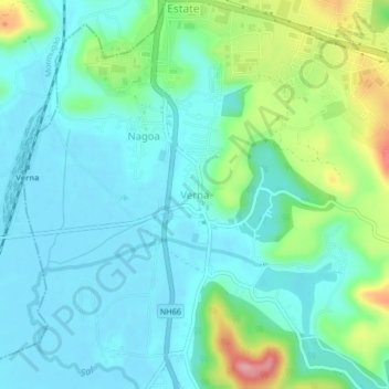
Name: Verna topographic map, elevation, terrain.

Location: Verna, Salcete, South Goa District, Goa, 403722, India (15.33103 73.91037 15.37103 73.95037)

Average elevation: 125 ft

Minimum elevation: 16 ft

Maximum elevation: 466 ft

Other topographic maps

Click on a map to view its topography, its elevation and its terrain.

Sal

India > Goa > Salcete > Parlmar Grande

Average elevation: 49 ft

Gear up for your next adventure:

🔊Portable Camp Speaker - Music and alerts at camp
Camping Coffee Makers - Enjoy premium coffee at the summit or campsite
🧥Waterproof Jacket for Hiking - Breathable and rugged rain jacket for outdoor excursions
🪶Wildlife Field Guides - Learn animal tracking and species ID
🧥Men's Rain Shells - Premium waterproof and breathable jackets for mountain weather

As an Amazon Associate, this site earns from qualifying purchases at no extra cost to you.