
Make a donation
Gear up for your next adventure:
As an Amazon Associate, this site earns from qualifying purchases at no extra cost to you.
New Harbour topographic map
Click on the map to display elevation.
Make a donation
Gear up for your next adventure:
As an Amazon Associate, this site earns from qualifying purchases at no extra cost to you.
About this map
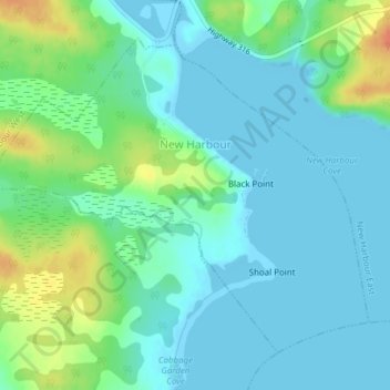
Name: New Harbour topographic map, elevation, terrain.
Average elevation: 36 ft
Minimum elevation: -3 ft
Maximum elevation: 135 ft
Make a donation
Gear up for your next adventure:
As an Amazon Associate, this site earns from qualifying purchases at no extra cost to you.
Other topographic maps
Click on a map to view its topography, its elevation and its terrain.
Clam Harbour Beach
Canada > Nova Scotia > Guysborough District Municipality > Manchester
Average elevation: 49 ft
Shingle Lake
Canada > Nova Scotia > Guysborough District Municipality > Forest Hill
Average elevation: 407 ft
Larry's River
Canada > Nova Scotia > Guysborough District Municipality > Larrys River
Average elevation: 16 ft