
Make a donation
Gear up for your next adventure:
As an Amazon Associate, this site earns from qualifying purchases at no extra cost to you.
Mine Hill topographic map
Click on the map to display elevation.
Make a donation
Gear up for your next adventure:
As an Amazon Associate, this site earns from qualifying purchases at no extra cost to you.
About this map
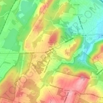
Name: Mine Hill topographic map, elevation, terrain.
Location: Mine Hill, Morris County, New Jersey, 07803, United States (40.86245 -74.62364 40.89814 -74.57820)
Average elevation: 804 ft
Minimum elevation: 577 ft
Maximum elevation: 1,024 ft
Morris County trails, hiking, mountain biking, running and outdoor activities
Make a donation
Gear up for your next adventure:
As an Amazon Associate, this site earns from qualifying purchases at no extra cost to you.
Other topographic maps
Click on a map to view its topography, its elevation and its terrain.
Shongum Lake Dam
United States > New Jersey > Morris County > Randolph Township
Average elevation: 837 ft
Make a donation
Gear up for your next adventure:
As an Amazon Associate, this site earns from qualifying purchases at no extra cost to you.
Lake Cherokee
United States > New Jersey > Morris County > Randolph Township > Calais Crossroads
Average elevation: 968 ft
Woodland Lake
United States > New Jersey > Morris County > Pequannock Township
Average elevation: 200 ft
Make a donation
Gear up for your next adventure:
As an Amazon Associate, this site earns from qualifying purchases at no extra cost to you.
Springtown
United States > New Jersey > Morris County > Washington Township > Long Valley
Average elevation: 886 ft
Prospect Point
United States > New Jersey > Morris County > Jefferson Township
Average elevation: 997 ft
Make a donation
Gear up for your next adventure:
As an Amazon Associate, this site earns from qualifying purchases at no extra cost to you.
Make a donation
Gear up for your next adventure:
As an Amazon Associate, this site earns from qualifying purchases at no extra cost to you.
Farny State Park
United States > New Jersey > Morris County > Rockaway Township
Average elevation: 951 ft
Lake Hiawatha
United States > New Jersey > Morris County > Parsippany-Troy Hills
Average elevation: 253 ft
Boonton Township
United States > New Jersey > Morris County > Boonton Township
Average elevation: 630 ft
Make a donation
Gear up for your next adventure:
As an Amazon Associate, this site earns from qualifying purchases at no extra cost to you.
Oak Ridge Dam
United States > New Jersey > Morris County > Jefferson Township
Average elevation: 873 ft
Make a donation
Gear up for your next adventure:
As an Amazon Associate, this site earns from qualifying purchases at no extra cost to you.
Make a donation
Gear up for your next adventure:
As an Amazon Associate, this site earns from qualifying purchases at no extra cost to you.
Florham Park
United States > New Jersey > Morris County > Florham Park > Florham Park
Average elevation: 230 ft
Make a donation
Gear up for your next adventure:
As an Amazon Associate, this site earns from qualifying purchases at no extra cost to you.
Tierneys Corner
United States > New Jersey > Morris County > Jefferson Township > Tierneys Corner
Average elevation: 988 ft
Coleman Hollow
United States > New Jersey > Morris County > Randolph Township > Coleman Hollow
Average elevation: 863 ft
Make a donation
Gear up for your next adventure:
As an Amazon Associate, this site earns from qualifying purchases at no extra cost to you.
Rockaway Township
United States > New Jersey > Morris County > Rockaway Township
Average elevation: 719 ft
Make a donation
Gear up for your next adventure:
As an Amazon Associate, this site earns from qualifying purchases at no extra cost to you.
Roxbury Township
United States > New Jersey > Morris County > Roxbury Township
Average elevation: 866 ft