
Ob River topographic map
Click on the map to display elevation.
Ob River
The combined Ob-Irtysh system, the fourth-longest river system of Asia (after Yenisei, and China's Yangzi and Yellow rivers), is 5,410 kilometres (3,360 mi) long, and the area of its basin 2,990,000 square kilometres (1,150,000 mi2). The river basin of the Ob consists mostly of steppe, taiga, swamps, tundra, and semi-desert topography. The floodplains of the Ob are characterised by many tributaries and lakes. The Ob is icebound at southern Barnaul from early in November to near the end of April, and at northern Salekhard, 150 km (93 mi) above its mouth, from the end of October to the beginning of June. The Ob River crosses several climatic zones. The upper Ob valley, in the south, supports grapes, melons and watermelons, whereas the lower reaches of the Ob are Arctic tundra. The most temperate climates on the Ob are at Biysk, Barnaul, and Novosibirsk.
About this map
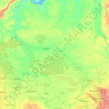
Name: Ob River topographic map, elevation, terrain.
Location: Ob River, Ural Federal District, Russia (52.30043 65.04695 66.78650 84.97333)
Average elevation: 400 ft
Minimum elevation: -3 ft
Maximum elevation: 6,391 ft
Other topographic maps
Click on a map to view its topography, its elevation and its terrain.
Ural Mountains
Russia > Khanty-Mansiysk Autonomous Okrug – Ugra > Beryozovsky District
The Ural Mountains (/ˈjʊərəl/ YOOR-əl; Russian: Ура́льские го́ры, tr. Uralskiye gory, IPA: [ʊˈralʲskʲɪjə ˈɡorɨ]; Bashkir: Урал тауҙары) or simply the Urals, are a mountain range in Eurasia that runs north-south mostly through Russia, from the coast of the Arctic Ocean to…
Average elevation: 4,708 ft
Siberia
Russia > Krasnoyarsk Krai > Boguchansky Rayon
Eastern and central Sakha comprises numerous north–south mountain ranges of various ages. These mountains extend up to almost 3,000 metres (9,800 ft), but above a few hundred metres they are almost completely devoid of vegetation. The Verkhoyansk Range was extensively glaciated in the Pleistocene, but the…
Average elevation: 1,135 ft
Sochi
Russia > Krasnodar Krai > Resort Town of Sochi (municipal formation)
Sochi has a humid subtropical climate (Köppen climate classification Cfa), at the lower elevations. Its average annual temperature is 18.9 °C (66.0 °F) during the day and 11.5 °C (52.7 °F) at night. In the coldest months—January and February—the average temperature is about 10 °C (50 °F) during the…
Average elevation: 486 ft
Dyatlov Pass
Russia > Sverdlovsk Oblast > Ивдельский муниципальный округ
Diaries and cameras found around their last campsite made it possible to track the group's route up to the day preceding the incident. On 31 January, the group arrived at the edge of a highland area and began to prepare for climbing. In a wooded valley, they cached surplus food and equipment that would be used…
Average elevation: 2,320 ft
Mount Elbrus (West Summit)
Russia > Karachay-Cherkessia > Karachayevsky District
As Elbrus is located in the Northern Hemisphere, the summer period takes place from June to mid-September, with an average of 50% of sunny days favorable to the ascent of the summit. However, the winds, dominated by westerly air masses, can turn violent and temperatures drop very quickly. Above 4000 meters…
Average elevation: 16,932 ft
East European Plain
Russia > Kostroma Oblast > Nerekhtsky District
The East European Plain (also called the Russian Plain, or historically the Sarmatic Plain) is a vast interior plain extending east of the North European Plain, and comprising several plateaus stretching roughly from 25 degrees longitude eastward. It includes Volhynian-Podolian Upland on its westernmost…
Average elevation: 377 ft
Greater Caucasus
Russia > Kabardino-Balkaria > Elbrus District
Most of the border of Russia with Georgia and Azerbaijan runs along most of the Caucasus' length. The Georgian Military Road (Darial Gorge) and Trans-Caucasus Highway traverse this mountain range at altitudes of up to 3,000 metres (9,800 ft).
Average elevation: 16,824 ft
Kurush
Russia > Dagestan > Dokuzparinsky District
Kurush (Russian: Куруш; Lezgian: Къуруш) is a mountain village located in the Dokuzparinsky District, in southern Dagestan. Situated at 2480–2560 m above sea level depending on the source (topographical maps show the center at about 2530 m), it is the highest continuously inhabited settlement of…
Average elevation: 8,186 ft
Kazbegi
Russia > Republic of North Ossetia – Alania > Prigorodny District
Kazbek is located on the Khokh Range, a mountain range which runs north of the Greater Caucasus Range, and which is pierced by the gorges of the Ardon and the Terek. At its eastern foot runs the Georgian Military Road through the pass of Darial 2,378 meters (7,805 feet). The mountain itself lies along the edge…
Average elevation: 14,186 ft
Moscow
Moscow is situated on the banks of the Moskva River, which flows for just over 500 km (311 mi) through the East European Plain in central Russia, not far from the natural border of the forest and forest-steppe zone. 49 bridges span the river and its canals within the city's limits. The elevation of Moscow at…
Average elevation: 522 ft
Mount Elbrus (East Summit)
Russia > Kabardino-Balkaria > Elbrus District
As Elbrus is located in the Northern Hemisphere, the summer period takes place from June to mid-September, with an average of 50% of sunny days favorable to the ascent of the summit. However, the winds, dominated by westerly air masses, can turn violent and temperatures drop very quickly. Above 4000 meters,…
Average elevation: 16,929 ft
Ivano-Osievskaya
Russia > Arkhangelsk Oblast > Верхнетоемский муниципальный округ
Average elevation: 125 ft
Dyatlov Pass
Russia > Sverdlovsk Oblast > Ивдельский муниципальный округ
Diaries and cameras found around their last campsite made it possible to track the group's route up to the day preceding the incident. On January 31, the group arrived at the edge of a highland area and began to prepare for climbing. In a wooded valley, they cached surplus food and equipment that would be used…
Average elevation: 2,320 ft
Oymyakon
Russia > Sakha Republic > Oymyakonsky Ulus
With an extreme subarctic climate (Köppen climate classification Dfd), Oymyakon is known as one of the places considered the Northern Pole of Cold, the other being the town of Verkhoyansk, located 629 km (391 mi) away by air. The weather station is in a valley between Oymyakon and Tomtor. The station is at…
Average elevation: 2,228 ft
Mount Narodnaya
Russia > Khanty-Mansiysk Autonomous Okrug – Ugra > Beryozovsky District
Mount Narodnaya (also known as Naroda and Poenurr; Russian: гора Народная, Komi: Народа-Из ("People's Mountain"), Mansi: Поэӈ-ур, Поэн-урр) is the highest peak of the Urals in Russia. Its elevation is 1,894 metres (6,214 ft). It is located on the border between Khanty–Mansi…
Average elevation: 4,715 ft
Kursk Oblast
The oblast, with an average elevation is 177–225 meters (580–738 ft), occupies the southern slopes of the middle-Russian plateau. The surface is hilly and intersected by ravines. The central part of Kursk oblast is more elevated than the Seym Valley to the west. The Timsko-Shchigrinsky ridge contains the…
Average elevation: 568 ft
Tunguska event
Russia > Krasnoyarsk Krai > Evenkiysky Rayon
The Tunguska event was a large explosion of between 3 and 50 megatons that occurred near the Podkamennaya Tunguska River in Yeniseysk Governorate (now Krasnoyarsk Krai), Russia, on the morning of 30 June 1908. The explosion over the sparsely populated East Siberian taiga felled a large number of trees, over an…
Average elevation: 1,093 ft
Ural Mountains
Russia > Khanty-Mansiysk Autonomous Okrug – Ugra > Beryozovsky District
The Ural Mountains (/ˈjʊərəl/ YOOR-əl; Russian: Уральские горы, tr. Urál'skiye góry, IPA: [ʊˈralʲskʲɪjə ˈɡorɨ]), or simply the Urals, is a mountain range in Eurasia that runs north-south mostly through Russia, from the coast of the Arctic Ocean to the river Ural and northwestern…
Average elevation: 4,708 ft
Yekaterinburg
Russia > Sverdlovsk Oblast > Yekaterinburg Municipality > Yekaterinburg
Average elevation: 899 ft
Lena River
Originating at an elevation of 1,640 meters (5,381 ft) at its source in the Baikal Mountains south of the Central Siberian Plateau, 7 kilometres (4 mi) west of Lake Baikal, the Lena flows northeast across the Lena-Angara Plateau, being joined by the Kirenga, Vitim and Olyokma. From Yakutsk it enters the…
Average elevation: 597 ft
Ural Mountains
Russia > Khanty-Mansiysk Autonomous Okrug – Ugra > Beryozovsky District
The Ural Mountains (/ˈjʊərəl/ YOOR-əl), or simply the Urals, are a mountain range in Eurasia that runs north–south mostly through Russia, from the coast of the Arctic Ocean to the river Ural and northwestern Kazakhstan. The mountain range forms part of the conventional boundary between the continents of…
Average elevation: 4,708 ft
Franz Josef Land
Russia > Arkhangelsk Oblast > Primorsky District
Approximately 85% of the archipelago is glaciated, with large unglaciated areas on the largest islands and many of the smallest ones. The islands have a combined coastline of 4,425 kilometers (2,750 mi). Compared to other Arctic archipelagos, Franz Josef Land is highly dissected, as a result of it being heavy…
Average elevation: 131 ft
Oymyakon
Russia > Sakha Republic > Oymyakonsky Ulus
With an extreme subarctic climate (Köppen climate classification Dfd, Trewartha climate classification Ecle), Oymyakon is known as one of the places considered the Northern Pole of Cold, the other being the town of Verkhoyansk, located 629 km (391 mi) away by air. The weather station is in a valley between…
Average elevation: 2,228 ft