
Make a donation
Gear up for your next adventure:
As an Amazon Associate, this site earns from qualifying purchases at no extra cost to you.
Union Bay Natural Area topographic map
Click on the map to display elevation.
Make a donation
Gear up for your next adventure:
As an Amazon Associate, this site earns from qualifying purchases at no extra cost to you.
About this map
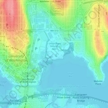
Name: Union Bay Natural Area topographic map, elevation, terrain.
Average elevation: 79 ft
Minimum elevation: -7 ft
Maximum elevation: 276 ft
King County trails, hiking, mountain biking, running and outdoor activities
Make a donation
Gear up for your next adventure:
As an Amazon Associate, this site earns from qualifying purchases at no extra cost to you.
Other topographic maps
Click on a map to view its topography, its elevation and its terrain.
Fritz Hedges Waterway Park
United States > Washington > King County > Seattle
Average elevation: 105 ft
Make a donation
Gear up for your next adventure:
As an Amazon Associate, this site earns from qualifying purchases at no extra cost to you.
Donnie Chin International Children’s Park
United States > Washington > King County > Seattle
Average elevation: 141 ft