
Make a donation
Gear up for your next adventure:
As an Amazon Associate, this site earns from qualifying purchases at no extra cost to you.
Elk Township topographic map
Click on the map to display elevation.
Make a donation
Gear up for your next adventure:
As an Amazon Associate, this site earns from qualifying purchases at no extra cost to you.
About this map
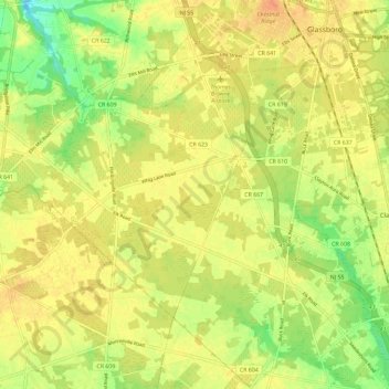
Name: Elk Township topographic map, elevation, terrain.
Average elevation: 135 ft
Minimum elevation: 59 ft
Maximum elevation: 177 ft
Gloucester County trails, hiking, mountain biking, running and outdoor activities
Make a donation
Gear up for your next adventure:
As an Amazon Associate, this site earns from qualifying purchases at no extra cost to you.
Other topographic maps
Click on a map to view its topography, its elevation and its terrain.
Williamstown
United States > New Jersey > Gloucester County > Monroe Township
Average elevation: 144 ft
Franklinville
United States > New Jersey > Gloucester County > Franklin Township
Average elevation: 105 ft
Make a donation
Gear up for your next adventure:
As an Amazon Associate, this site earns from qualifying purchases at no extra cost to you.
Monroe Township
United States > New Jersey > Gloucester County > Monroe Township
Average elevation: 125 ft
Verga
United States > New Jersey > Gloucester County > West Deptford Township
Average elevation: 23 ft
Make a donation
Gear up for your next adventure:
As an Amazon Associate, this site earns from qualifying purchases at no extra cost to you.
Clarksboro
United States > New Jersey > Gloucester County > East Greenwich Township
Average elevation: 46 ft
Buckingham Village
United States > New Jersey > Gloucester County > Mantua Township
Average elevation: 79 ft
Make a donation
Gear up for your next adventure:
As an Amazon Associate, this site earns from qualifying purchases at no extra cost to you.
Mantua Creek
United States > New Jersey > Gloucester County > West Deptford Township
Average elevation: 43 ft
Mickleton
United States > New Jersey > Gloucester County > East Greenwich Township
Average elevation: 59 ft
Hurffville
United States > New Jersey > Gloucester County > Washington Township > Hurffville
Average elevation: 85 ft
Make a donation
Gear up for your next adventure:
As an Amazon Associate, this site earns from qualifying purchases at no extra cost to you.
Sunset Beach
United States > New Jersey > Gloucester County > Deptford > Sunset Beach
Average elevation: 56 ft
Bridgeport
United States > New Jersey > Gloucester County > Logan Township > Bridgeport
Average elevation: 13 ft
Westcotville
United States > New Jersey > Gloucester County > Deptford Township
Average elevation: 52 ft