
Make a donation
Gear up for your next adventure:
As an Amazon Associate, this site earns from qualifying purchases at no extra cost to you.
Clearwater River topographic map
Click on the map to display elevation.
Make a donation
Gear up for your next adventure:
As an Amazon Associate, this site earns from qualifying purchases at no extra cost to you.
Clearwater River
From Broach Lake at an elevation of 460 metres (1,510 ft) above sea level, the Clearwater drops about 150 metres (490 ft) to the confluence at Fort McMurray. Its waters eventually reach the Arctic Ocean via the Athabasca and Mackenzie Rivers. Tributaries of the Clearwater River include Descharme River and McLean River in Saskatchewan and the Christina River in Alberta.
Make a donation
Gear up for your next adventure:
As an Amazon Associate, this site earns from qualifying purchases at no extra cost to you.
About this map
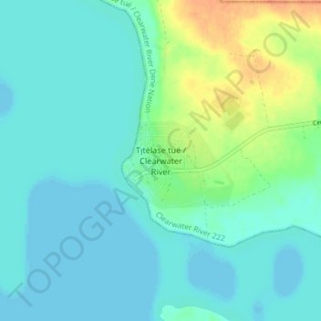
Name: Clearwater River topographic map, elevation, terrain.
Average elevation: 1,476 ft
Minimum elevation: 1,447 ft
Maximum elevation: 1,562 ft
Make a donation
Gear up for your next adventure:
As an Amazon Associate, this site earns from qualifying purchases at no extra cost to you.
Other topographic maps
Click on a map to view its topography, its elevation and its terrain.
Delaronde Lake
Canada > Saskatchewan > Division No. 18 > Unorganized Division No. 18
Average elevation: 1,699 ft
Churchill River
Canada > Saskatchewan > Division No. 18 > Unorganized Division No. 18
Average elevation: 1,375 ft
Read Lake
Canada > Saskatchewan > Division No. 18 > Unorganized Division No. 18
Average elevation: 1,253 ft