
Make a donation
Gear up for your next adventure:
As an Amazon Associate, this site earns from qualifying purchases at no extra cost to you.
Burnaby Island topographic map
Click on the map to display elevation.
Make a donation
Gear up for your next adventure:
As an Amazon Associate, this site earns from qualifying purchases at no extra cost to you.
About this map
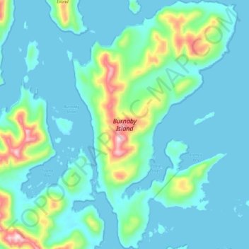
Name: Burnaby Island topographic map, elevation, terrain.
Average elevation: 292 ft
Minimum elevation: -3 ft
Maximum elevation: 1,962 ft
Make a donation
Gear up for your next adventure:
As an Amazon Associate, this site earns from qualifying purchases at no extra cost to you.
Other topographic maps
Click on a map to view its topography, its elevation and its terrain.
Sandspit
Canada > British Columbia > North Coast Regional District > Area E (Moresby Island)
Average elevation: 43 ft
Alford Point
Canada > British Columbia > North Coast Regional District > Area E (Moresby Island)
Average elevation: 200 ft
Sandspit
Canada > British Columbia > North Coast Regional District > Area E (Moresby Island)
Average elevation: 43 ft