
Nokomis topographic map
Click on the map to display elevation.
Nokomis
Nokomis features a predominantly flat and low-lying terrain characteristic of the coastal region. The elevation in Nokomis rarely exceeds 15 feet above sea level, contributing to its vulnerability to tidal influences and storm surges. The area is interspersed with wetlands and mangroves, particularly near the shores of the Gulf of Mexico, which are essential for local ecosystems. Sand dunes along Nokomis Beach provide a natural barrier and support native vegetation, while the surrounding landscape consists of residential developments intermingled with pockets of lush greenery. The nearby Legacy Trail, which runs through this relatively flat terrain, offers scenic views and access to the area's natural beauty, showcasing the unique blend of coastal and wetland environments.
About this map
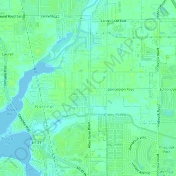
Name: Nokomis topographic map, elevation, terrain.
Location: Nokomis, Sarasota County, Florida, United States (27.10853 -82.45906 27.13793 -82.41717)
Average elevation: 16 ft
Minimum elevation: -7 ft
Maximum elevation: 33 ft
Sarasota County trails, hiking, mountain biking, running and outdoor activities
Other topographic maps
Click on a map to view its topography, its elevation and its terrain.
Sarasota
United States > Florida > Sarasota County
Sarasota is characterized by predominantly flat topography with an average elevation of about 25 feet (approximately 8 meters) above sea level. The area features gently rolling terrain and is primarily composed of coastal plains. These low-lying regions are interspersed with wetlands and several small lakes,…
Average elevation: 23 ft
Venice
United States > Florida > Sarasota County
Venice is characterized by its predominantly flat terrain, situated at an elevation of approximately 15 feet above sea level. This coastal city features sandy beaches along the Gulf of Mexico and is interspersed with various waterways, including canals and lakes that contribute to its scenic environment. The…
Average elevation: 10 ft
North Port
United States > Florida > Sarasota County
North Port features a predominantly flat and low-lying topography characteristic of the region. The area is situated at an elevation of approximately 20 feet above sea level, with much of the terrain comprising wetlands, pine forests, and small lakes, interspersed with residential developments. The Myakka…
Average elevation: 20 ft
Toll Brothers at Venice Woodlands
United States > Florida > Sarasota County > Venice
Average elevation: 16 ft