
North Port topographic map
Click on the map to display elevation.
North Port
North Port features a predominantly flat and low-lying topography characteristic of the region. The area is situated at an elevation of approximately 20 feet above sea level, with much of the terrain comprising wetlands, pine forests, and small lakes, interspersed with residential developments. The Myakka River runs to the west of the city, contributing to the landscape's natural beauty and providing vital ecosystems for local wildlife. Additionally, the city's proximity to the Gulf Coast means that coastal influences subtly shape the environment, making the terrain not only diverse but also rich in recreational opportunities, such as hiking and boating in the nearby waterways.
About this map
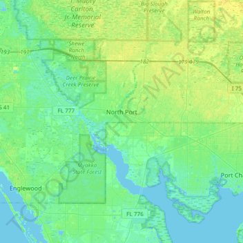
Name: North Port topographic map, elevation, terrain.
Location: North Port, Sarasota County, Florida, United States (26.94536 -82.35257 27.12187 -82.05732)
Average elevation: 20 ft
Minimum elevation: -16 ft
Maximum elevation: 46 ft
Sarasota County trails, hiking, mountain biking, running and outdoor activities
Other topographic maps
Click on a map to view its topography, its elevation and its terrain.
Englewood
United States > Florida > Sarasota County > Englewood
Englewood features predominantly flat and low-lying terrain typical of the region's coastal landscape. The average elevation here is approximately 15 feet above sea level, which makes the area particularly susceptible to tidal influences and storm surges. The terrain is interspersed with wetlands and…
Average elevation: 10 ft
Nokomis
United States > Florida > Sarasota County
Nokomis features a predominantly flat and low-lying terrain characteristic of the coastal region. The elevation in Nokomis rarely exceeds 15 feet above sea level, contributing to its vulnerability to tidal influences and storm surges. The area is interspersed with wetlands and mangroves, particularly near the…
Average elevation: 16 ft
Venice Area Audubon Rookery
United States > Florida > Sarasota County > South Venice > Venice Groves
Average elevation: 20 ft
Gulf Gate Estates
United States > Florida > Sarasota County > Gulf Gate Estates
Average elevation: 23 ft
Toll Brothers at Venice Woodlands
United States > Florida > Sarasota County > Venice
Average elevation: 16 ft
South Gate Ridge
United States > Florida > Sarasota County > South Gate Ridge
Average elevation: 39 ft
Ridge Wood Heights
United States > Florida > Sarasota County > Ridge Wood Heights
Average elevation: 33 ft