
忠县 topographic map
Interactive map
Click on the map to display elevation.
About this map
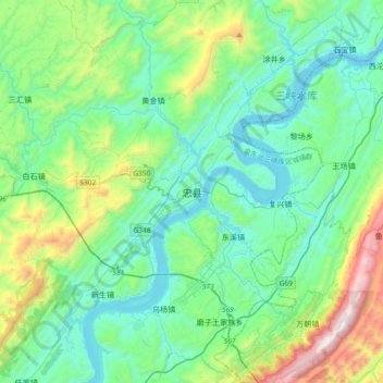
Name: 忠县 topographic map, elevation, terrain.
Location: 忠县, 渝东北三峡库区城镇群, 重庆市, 中国 (30.14209 107.87524 30.46209 108.19524)
Average elevation: 1,453 ft
Minimum elevation: 348 ft
Maximum elevation: 5,505 ft
忠县境内以低山与槽谷丘陵为主,海拔差异大,最低点为石宝镇长江河谷(海拔117.5米),最高点为方斗山主峰(海拔1680.3米)。全县低山起伏,是“三山两向斜”的典型丘陵地貌。
Other topographic maps
Click on a map to view its topography, its elevation and its terrain.