
Skipton topographic map
Click on the map to display elevation.
About this map
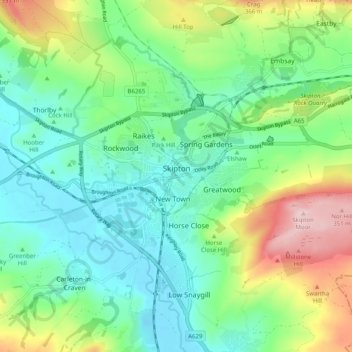
Name: Skipton topographic map, elevation, terrain.
Average elevation: 568 ft
Minimum elevation: 292 ft
Maximum elevation: 1,204 ft
Other topographic maps
Click on a map to view its topography, its elevation and its terrain.
Battersby Junction
United Kingdom > England > North Yorkshire > Ingleby Greenhow
Average elevation: 535 ft
Bolton Castle
United Kingdom > England > North Yorkshire > Redmire > Castle Bolton
Average elevation: 820 ft
Thimbleby & Osmotherly Show field
United Kingdom > England > North Yorkshire > Thimbleby
Average elevation: 499 ft
Easby Moor
United Kingdom > England > North Yorkshire > Easby > Little Ayton
Average elevation: 604 ft
Killinghall
United Kingdom > England > North Yorkshire > Harrogate > Killinghall
Average elevation: 282 ft
Arkle Town
United Kingdom > England > North Yorkshire > Richmondshire > Arkle Town
Average elevation: 1,204 ft
Swinithwaite
United Kingdom > England > North Yorkshire > Richmondshire > West Witton > Swinithwaite
Average elevation: 673 ft