Geolocate

Seligman topographic map

Click on the map to display elevation.

👉 Easily get elevation data in JSON, GeoTIFF and KML formats using Elevation API
Thank you for supporting this site ❤️
Make a donation

Seligman

Seligman is located at 35°19′42″N 112°52′27″W / 35.32833°N 112.87417°W / 35.32833; -112.87417 (35.328199, −112.874303), at 5,240 feet (1,600 m) in elevation, alongside the Big Chino Wash, in a northern section of Chino Valley. The wash is a major tributary of the Verde River. Seligman is a popular stopping point along Historic U.S. Route 66.

Wikipedia (CC-BY-SA 3.0)

About this map

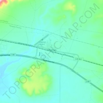
Name: Seligman topographic map, elevation, terrain.

Location: Seligman, Yavapai County, Arizona, 86337, United States (35.31021 -112.90659 35.34077 -112.80392)

Average elevation: 5,305 ft

Minimum elevation: 5,125 ft

Maximum elevation: 6,165 ft

Yavapai County trails, hiking, mountain biking, running and outdoor activities

Other topographic maps

Click on a map to view its topography, its elevation and its terrain.

Mayer

United States > Arizona > Yavapai County

Average elevation: 4,682 ft

Black Canyon City

United States > Arizona > Yavapai County

Black Canyon City is located at 34°4′11″N 112°8′22″W / 34.06972°N 112.13944°W / 34.06972; -112.13944 (34.069719, -112.139466), at an elevation of 1,975 feet (602 m).

Average elevation: 2,297 ft

Paradise Acres

United States > Arizona > Yavapai County > Camp Verde

Average elevation: 3,110 ft

Tapco

United States > Arizona > Yavapai County

Average elevation: 3,553 ft

Walker

United States > Arizona > Yavapai County

Average elevation: 6,690 ft

Seligman

United States > Arizona > Yavapai County > Seligman

Seligman is located at 35°19′42″N 112°52′27″W / 35.32833°N 112.87417°W / 35.32833; -112.87417 (35.328199, −112.874303), at 5,240 feet (1,600 m) in elevation, alongside the Big Chino Wash, in a northern section of Chino Valley. The wash is a major tributary of the Verde River. Seligman is…

Average elevation: 5,305 ft

Cleator

United States > Arizona > Yavapai County

Average elevation: 3,553 ft

Woodchute Mountain

United States > Arizona > Yavapai County

Average elevation: 7,110 ft

Granite Mountain

United States > Arizona > Yavapai County

Average elevation: 6,283 ft

Clear Creek

United States > Arizona > Yavapai County > Camp Verde

Average elevation: 3,130 ft

Cedar Bench Wilderness

United States > Arizona > Yavapai County

Cedar Bench Wilderness is a protected wilderness area in the Prescott National Forest in the U.S. state of Arizona. Established in 1984 under the Arizona Wilderness Act, the area protects the large "bench" that divides the Agua Fria and Verde River drainages. Elevations range from 4,500 feet (1,371 m) to 6,700…

Average elevation: 4,426 ft

Ocotillo

United States > Arizona > Yavapai County

Average elevation: 4,272 ft

Clarkdale

United States > Arizona > Yavapai County

Average elevation: 3,973 ft

Kirkland

United States > Arizona > Yavapai County

Average elevation: 4,029 ft

Chimney Rock

United States > Arizona > Yavapai County

Average elevation: 4,728 ft

Verde Village

United States > Arizona > Yavapai County

Average elevation: 3,412 ft

Glen Oaks

United States > Arizona > Yavapai County

Average elevation: 5,633 ft

Ash Fork

United States > Arizona > Yavapai County

Average elevation: 5,171 ft

Willow Spring

United States > Arizona > Yavapai County

Average elevation: 4,747 ft

Miller Valley

United States > Arizona > Yavapai County > Prescott

Average elevation: 5,456 ft

Briggs

United States > Arizona > Yavapai County

Average elevation: 3,084 ft

Yava

United States > Arizona > Yavapai County

Average elevation: 3,593 ft

Gear up for your next adventure:

🧭Compass with Lanyard - Easy‑carry compass for navigation
🥾Men's Hiking Boots - Durable, waterproof footwear for rugged terrain and steep inclines
🛶Inflatable Kayak - Portable kayak for rivers, lakes, and expeditions
🛰️Satellite Messengers - Emergency SOS and two-way messaging for off-grid adventures
Solar GPS Watches - Advanced multisport watches with built-in topographic maps

As an Amazon Associate, this site earns from qualifying purchases at no extra cost to you.