
Diadema topographic map
Click on the map to display elevation.
About this map
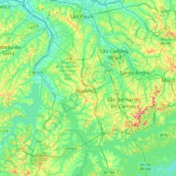
Name: Diadema topographic map, elevation, terrain.
Average elevation: 2,533 ft
Minimum elevation: 2,336 ft
Maximum elevation: 3,117 ft
Other topographic maps
Click on a map to view its topography, its elevation and its terrain.
Campanário
Brasil > São Paulo > Região Metropolitana de São Paulo > Diadema
Average elevation: 2,628 ft
Praça da Moça
Brasil > São Paulo > Região Metropolitana de São Paulo > Diadema
Average elevation: 2,638 ft
Parque do Paço
Brasil > São Paulo > Região Metropolitana de São Paulo > Diadema
Average elevation: 2,605 ft
Conceição
Brasil > São Paulo > Região Metropolitana de São Paulo > Diadema
Average elevation: 2,631 ft