
Thank you for supporting this site ❤️
Make a donation
Make a donation
Gear up for your next adventure:
As an Amazon Associate, this site earns from qualifying purchases at no extra cost to you.
Conceição topographic map
Click on the map to display elevation.
Thank you for supporting this site ❤️
Make a donation
Make a donation
Gear up for your next adventure:
As an Amazon Associate, this site earns from qualifying purchases at no extra cost to you.
About this map
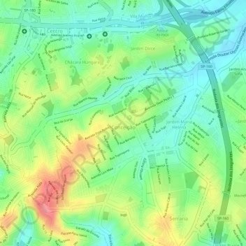
Name: Conceição topographic map, elevation, terrain.
Average elevation: 2,631 ft
Minimum elevation: 2,503 ft
Maximum elevation: 2,822 ft
Thank you for supporting this site ❤️
Make a donation
Make a donation
Gear up for your next adventure:
As an Amazon Associate, this site earns from qualifying purchases at no extra cost to you.
Other topographic maps
Click on a map to view its topography, its elevation and its terrain.
Praça da Moça
Brasil > São Paulo > Região Metropolitana de São Paulo > Diadema
Average elevation: 2,638 ft
Parque do Paço
Brasil > São Paulo > Região Metropolitana de São Paulo > Diadema
Average elevation: 2,605 ft