
Lost River topographic map
Click on the map to display elevation.
About this map
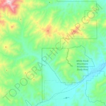
Name: Lost River topographic map, elevation, terrain.
Location: Lost River, Custer County, Idaho, United States (43.66949 -113.65445 43.82447 -113.42586)
Average elevation: 7,211 ft
Minimum elevation: 5,899 ft
Maximum elevation: 11,204 ft
Custer County trails, hiking, mountain biking, running and outdoor activities
Other topographic maps
Click on a map to view its topography, its elevation and its terrain.
Stanley Lake
United States > Idaho > Custer County
The lake is approximately seven miles (11 km) west of Stanley, readily accessed via a three-mile (5 km) spur road from State Highway 21. The surface elevation of the lake is 6,513 feet (1,985 m) above sea level.
Average elevation: 6,808 ft